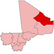
Anéfis
Anefif | |
|---|---|
Commune and village | |
| Coordinates: 18°2′40″N 0°36′10″E / 18.04444°N 0.60278°E | |
| Country | |
| Region | Kidal Region |
| Cercle | Kidal Cercle |
| Area | |
• Total | 2,800 km2 (1,100 sq mi) |
| Population (2009)[2] | |
• Total | 5,087 |
| • Density | 1.8/km2 (4.7/sq mi) |
| Time zone | UTC+0 (GMT) |
Anefif or Anéfis is a Saharan village and commune in the Cercle of Kidal in the Kidal Region of north-eastern Mali.
Geography
Anefif is located on the Tessalit Trail. It lies 95 km (59 mi) southwest of Kidal on the route linking Kidal to Bourem and Gao. In 2009 the commune had a population of 5,087.[2]
There are multiple rocks and stones made from volcanic material.[3]
History
In 2013, the Malian Military attacked Tuareg rebels living in the village. The war was highly criticized by the military, and the press, who claimed that it was too invasive and violent.[4]
Climate
The commune has a Saharian climate and is too dry for rain-fed agriculture. The annual rainfall of around 150 mm occurs between late June and early September.[1]
Kel Adagh
There are many Kel Adagh in the area, along with multiple small clans.[5]
Notable people
- Abdullah Senussi - Head of Libyan Military Intelligence (born 1949).[6]
References
- ^ a b Programme de renforcement des capacités nationales pour une gestion stratégique du développement (PRECAGED): Schéma d'aménagement et de développement de la Commune Rurale Anefif (in French), République du Mali: Ministère de l'économie programme des nations unies et des finances, 2004, archived from the original on 2012-03-17.
- ^ a b Resultats Provisoires RGPH 2009 (Région de Kidal) (PDF), République de Mali: Institut National de la Statistique, archived from the original (PDF) on 2011-07-22.
- ^ Bertrand, J. M.; Bertrand-Sarfati, J.; Bessoles, B. (2013-10-22). Afrique de l'Ouest: Introduction Géologique et Termes Stratigraphiques (in French). Elsevier. ISBN 978-1-4831-3826-8.
- ^ Ahmed, Baba (5 June 2013). "Malian army takes Anefis, 1st territorial gain". The San Diego Union Tribune. Retrieved 26 July 2020.
- ^ Badi, Dida (2001-12-31). "Une expérience de recherche sur un terrain saharien : l'Adagh des Ifoughas". Insaniyat / إنسانيات. Revue algérienne d'anthropologie et de sciences sociales (in French) (14–15): 129–147. doi:10.4000/insaniyat.9643. ISSN 1111-2050 – via OpenEdition.org.
- ^ "Council Implementing Regulation (EU) No 1103/2014". Official Journal of the European Union. 20 October 2014 – via EUR-Lex.
External links
- Plan de Sécurité Alimentaire Commune Rurale de Anefif 2007-2011 (PDF) (in French), Commissariat à la Sécurité Alimentaire, République du Mali, USAID-Mali, 2007, archived from the original (PDF) on 2012-09-20, retrieved 2012-04-23.


