
Avalanche Peak (Wyoming)
| Avalanche Peak | |
|---|---|
 | |
| Highest point | |
| Elevation | 10,568 ft (3,221 m)[1] |
| Prominence | 1,008 ft (307 m)[1] |
| Parent peak | Silvertip Peak (10,645 ft)[2] |
| Isolation | 2.99 mi (4.81 km)[2] |
| Coordinates | 44°29′22″N 110°08′24″W / 44.4894150°N 110.1399822°W[3] |
| Geography | |
 Avalanche Peak Location in Wyoming  Avalanche Peak Avalanche Peak (the United States) | |
| Location | Yellowstone National Park Park County, Wyoming, U.S. |
| Parent range | Absaroka Range Rocky Mountains |
| Topo map | USGS Sylvan Lake |
| Climbing | |
| Easiest route | Trail |
Avalanche Peak is a 10,568-foot (3,221 m) summit located on the shared border of Yellowstone National Park and North Absaroka Wilderness, in Park County, Wyoming.[3] It is part of the Absaroka Range.[4] It features a large bowl covered in scree and is popular with hikers for its view of Yellowstone Lake and the surrounding area.[5] The mountain's name was officially adopted in 1930 by the United States Board on Geographic Names.[6]
Climate[edit]
According to the Köppen climate classification system, Avalanche Peak is located in a subarctic climate zone with long, cold, snowy winters, and mild summers.[7] Winter temperatures can drop below −10 °F with wind chill factors below −30 °F.
Gallery[edit]
-
 Avalanche Peak across Yellowstone Lake
 -
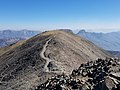 Summit of Avalanche Peak
 -
 Summit of Avalanche Peak
.jpg)
.jpg)

See also[edit]
References[edit]
- ^ a b "Avalanche Peak, Wyoming". Peakbagger.com. Retrieved 2021-11-12.
- ^ a b "Avalanche Peak - 10,568' WY". listsofjohn.com. Retrieved 2021-11-12.
- ^ a b "Avalanche Peak". Geographic Names Information System. United States Geological Survey, United States Department of the Interior. Retrieved 2021-11-12.
- ^ "Avalanche Peak : Climbing, Hiking & Mountaineering : SummitPost". www.summitpost.org.
- ^ "Avalanche Peak Trail (U.S. National Park Service)". www.nps.gov.
- ^ Decisions of the United States Geographic Board, Place Names, Yellowstone National Park, Wyo. May 7, 1930. page 2.
- ^ Peel, M. C.; Finlayson, B. L.; McMahon, T. A. (2007). "Updated world map of the Köppen−Geiger climate classification". Hydrol. Earth Syst. Sci. 11 (5): 1633. Bibcode:2007HESS...11.1633P. doi:10.5194/hess-11-1633-2007. ISSN 1027-5606. S2CID 9654551.
External links[edit]
- Weather forecast: Avalanche Peak
- Avalanche Peak Trail: National Park Service
This article related to a mountain, mountain range, or peak in the United States is a stub. You can help Wikipedia by expanding it. |