
Ballybofey
Ballybofey
Bealach Féich | |
|---|---|
Town | |
 The N15 road passes through Ballybofey | |
 Ballybofey Location in Ireland | |
| Coordinates: 54°48′00″N 7°47′24″W / 54.8°N 7.790°W | |
| Country | Ireland |
| Province | Ulster |
| County | County Donegal |
| Elevation | 30 m (100 ft) |
| Population | 4,852 |
| Time zone | UTC+0 (WET) |
| • Summer (DST) | UTC+1 (IST (WEST)) |
| Irish Grid Reference | H194946 |
| Website | ballybofeystranorlar |
| Year | Pop. | ±% |
|---|---|---|
| 1821 | 1,671 | — |
| 1831 | 1,515 | −9.3% |
| 1841 | 1,167 | −23.0% |
| 1851 | 1,297 | +11.1% |
| 1861 | 1,404 | +8.2% |
| 1871 | 1,349 | −3.9% |
| 1881 | 1,429 | +5.9% |
| 1891 | 1,219 | −14.7% |
| 1901 | 1,203 | −1.3% |
| 1911 | 1,189 | −1.2% |
| 1926 | 1,250 | +5.1% |
| 1936 | 1,198 | −4.2% |
| 1946 | 1,256 | +4.8% |
| 1951 | 1,274 | +1.4% |
| 1956 | 1,586 | +24.5% |
| 1961 | 1,878 | +18.4% |
| 1966 | 1,942 | +3.4% |
| 1971 | 2,214 | +14.0% |
| 1981 | 2,928 | +32.2% |
| 1986 | 2,964 | +1.2% |
| 1991 | 2,972 | +0.3% |
| 1996 | 3,047 | +2.5% |
| 2002 | 3,603 | +18.2% |
| 2006 | 4,176 | +15.9% |
| 2011 | 4,852 | +16.2% |
| [2][3][4][5][6] | ||

Ballybofey (/ˌbælibəˈfeɪ/ BAL-ee-bə-FAY, locally /ˌbælbəˈfeɪ/ BAL-bə-FAY; Irish: Bealach Féich, meaning "Fiach's pass") is a town located on the south bank of the River Finn, County Donegal, Ireland. Together with the smaller town of Stranorlar on the north side of the River Finn, the towns form the Twin Towns of Ballybofey-Stranorlar. Ballybofey-Stranorlar, a census town, had a population of 4,852 in 2016.[1]
History[edit]
A few miles west of Ballybofey, on the main road to Fintown (the R252 regional road), is the Glenmore Estate, located at Welchtown. The estate formerly included Glenmore Lodge, a country house that stood on the opposite, southern bank of the River Finn, near Glenmore Bridge. The house was originally built in the Georgian-style in the mid-to-late-18th-century. It was reworked for Sir William Styles in the neo-Tudor-style in the early 20th century. The house was demolished in the 1990s. The private estate is now known for its fishing and hunting.[7]
The town grew rapidly in the 19th and 20th centuries. There are no schools or churches in the town of Ballybofey itself, with all these amenities lying either across the bridge in Stranorlar or outside the town limits. This is due to laws during plantation times when certain Catholic buildings were not allowed within a specified range of Protestant towns, in this case Stranorlar, though Stranorlar now has both a Roman Catholic and a Church of Ireland church.

Events[edit]
Ballybofey previously played host to an annual Twin Towns Festival. The last of these took place in August 2007.[8]
The Balor Arts Centre is a 300-seat arts and theatre complex,[9] and Butt Drama Circle is a local amateur drama group.[10]
Sport[edit]
Ballybofey is home to Finn Park where League of Ireland side Finn Harps play their home games.[11] Seán MacCumhaill Park is also located in Ballybofey, where the Donegal senior football team have their county office and play most of their home games.[12]
Transport[edit]
Ballybofey railway station opened on 3 June 1895, but closed on 15 December 1947.[13]
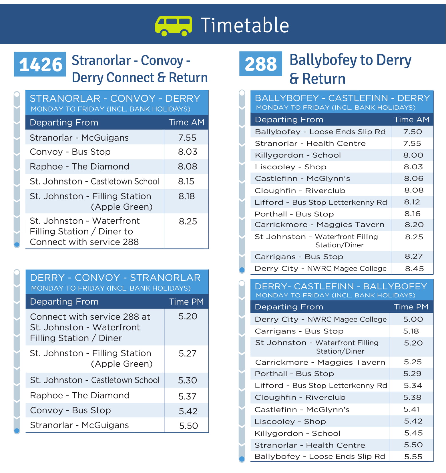
Bus Éireann routes 64 (Derry/Galway)[14] and 480 (Ballybofey/Derry)[15] pass through the town.
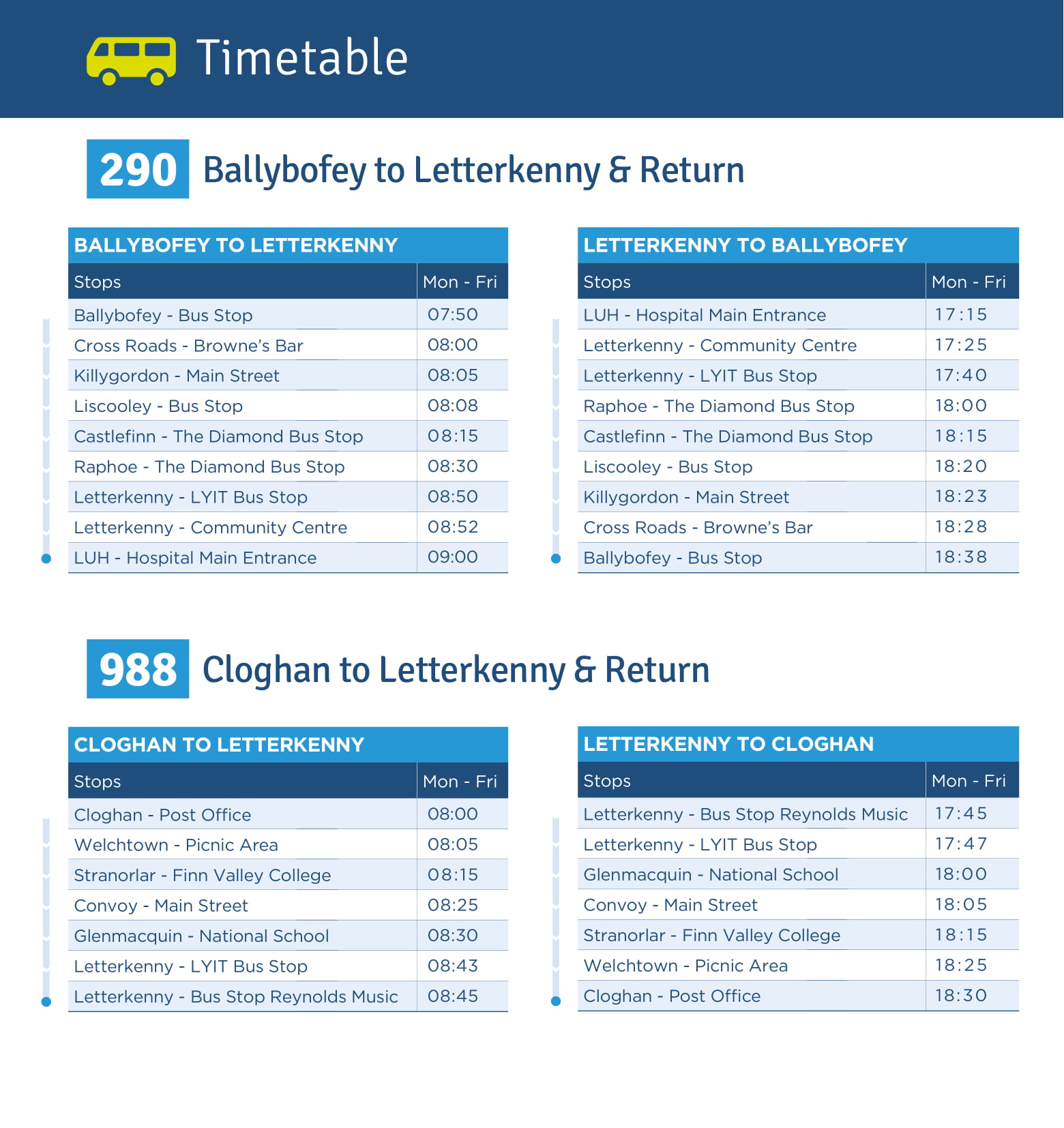
TFI Local Link route 264 (Ballyshannon/Letterkenny),[16] 288 (Ballybofey/Derry)[17] and 290 (Ballybofey/Letterkenny)[18] all service the town.
People[edit]
- Joseph Barclay Pentland (1797–1873) – geographer, natural scientist, and traveller.[19]
- Isaac Butt (1813–1879) – politician, leader of the Home Rule League, born a short distance away in Glenfin, where the Isaac Butt Memorial Hall stands[20]
- Oisín Gallen – footballer[21]
- Jimmy Kelly (1911–1970) – footballer[citation needed]
- Ernan McMullin (1924–2011) – philosopher[22]
- Conal Gallen (born 1955) – singer and comedian.[23]
- Gerald Porter (born 1968) – darts player[citation needed]
- John Dunleavy (born 1991) – footballer[24]
- Jason Quigley (born 1991) – boxer[25][26]
See also[edit]
- List of populated places in Ireland
- List of market houses in the Republic of Ireland
- Stranorlar County Mother & Baby Home
References[edit]
- ^ a b "Sapmap Area – Settlements – Ballybofey-Stranorlar". Census 2016. CSO. 2016. Archived from the original on 13 January 2018. Retrieved 12 January 2018.
- ^ "Census for post 1821 figures". Cso.ie. Archived from the original on 20 September 2010. Retrieved 18 February 2012.
- ^ "The Online Historical Population Reports Website". Histpop. Archived from the original on 7 May 2016. Retrieved 18 February 2012.
- ^ "Northern Ireland Statistics and Research Agency – Census Home Page". Nisranew.nisra.gov.uk. Archived from the original on 17 February 2012. Retrieved 18 February 2012.
- ^ Lee, JJ (1981). "On the accuracy of the Pre-famine Irish censuses". In Goldstrom, J. M.; Clarkson, L. A. (eds.). Irish Population, Economy, and Society: Essays in Honour of the Late K. H. Connell. Oxford, England: Clarendon Press.
- ^ Mokyr, Joel; O Grada, Cormac (November 1984). "New Developments in Irish Population History, 1700–1850". The Economic History Review. 37 (4): 473–488. doi:10.1111/j.1468-0289.1984.tb00344.x. hdl:10197/1406. Archived from the original on 4 December 2012.
- ^ Rowan, Prof. Alistair (1979). Buildings of Ireland: North West Ulster. London: Penguin Books. p. 564. ISBN 0-300-09667-4.
- ^ "Donegal Direct". Donegal Direct. Archived from the original on 8 February 2012. Retrieved 18 February 2012.
- ^ "Balor Arts Centre | Donegal Diaspora". www.donegaldiaspora.ie. Archived from the original on 15 January 2021. Retrieved 8 December 2020.
- ^ "Butt Drama Circle to perform Brian Friel classic". Donegal News. 20 February 2017. Archived from the original on 14 November 2017. Retrieved 8 December 2020.
- ^ "Finn Harps website". Finn Harps F.C. Archived from the original on 6 September 2006. Retrieved 18 February 2012.
- ^ "Sean Mac Cumhaills". CLG Dhún na nGall. Archived from the original on 10 December 2019. Retrieved 8 December 2020.
- ^ "Ballybofey station" (PDF). Railscot – Irish Railways. Archived (PDF) from the original on 26 September 2007. Retrieved 10 September 2007.
- ^ "Expressway Timetable Route 64, Galway - Derry - Bus Éireann - View Ireland Bus and Coach Timetables & Buy Tickets". www.buseireann.ie. Retrieved 19 August 2023.
- ^ "Bus Éireann Timetable Route 480, Derry - Donegal - Ballyshannon - Sligo - Bus Éireann - View Ireland Bus and Coach Timetables & Buy Tickets". www.buseireann.ie. Retrieved 19 August 2023.
- ^ "123968 SITT TT 264 Ballyshannon to Letterkenny 4pg DL" (PDF). Local Link Donegal-Sligo-Leitrim. Retrieved 19 August 2023.
- ^ "426-288-Stranorlar-to-Derry-2.jpg" (JPG). Local Link Donegal-Sligo-Leitrim. Retrieved 19 August 2023.
- ^ "290-988-Ballybofey-Cloghan-to-Letterkenny-TT.jpg" (JPG). Local Link Donegal-Sligo-Leitrim. Retrieved 19 August 2023.
- ^ "Joseph Barclay Pentland". newulsterbiography.co.uk. Dictionary of Ulster Biography. Retrieved 24 March 2022.
- ^ Reid, Colin W. (2014). "'An Experiment in Constructive Unionism': Isaac Butt, Home Rule and Federalist Political Thought during the 1870s". The English Historical Review. 129 (537): 332–361.
- ^ "Oisín Gallen wins Gradam Shéamuis Mhic Géidigh". Ocean FM. 13 December 2023. Retrieved 13 December 2023.
- ^ "Sad Passing of Brilliant Donegal Priest Who Became Professor Emeritus of Philisophy[sic] at Amercian[sic] University". Donegal Daily. 10 February 2011. Retrieved 24 March 2022.
- ^ "Conal set to leave them laughing in TG4 series". Donegal Democrat. 12 October 2011. Archived from the original on 28 July 2012. Retrieved 24 March 2022.
- ^ "Barnet sign John Dunleavy on loan from Wolves". BBC Sport. 24 March 2022.
- ^ "'When he said 'from Ballybofey, Donegal'... The legs went". the42.ie. Journal Media Ltd. 3 June 2021. Retrieved 21 November 2021.
- ^ "Amazing Mural of Jason Quigley Unveiled in Twin Towns". donegaldaily.com. 18 November 2021. Retrieved 21 November 2021.
mural of boxer Jason Quigley has been unveiled in his hometown Ballybofey
External links[edit]

| International | |
|---|---|
| National | |
| Geographic | |