
Bangar, Brunei
Bangar
Pekan Bangar | |
|---|---|
Town | |
| Bangar Town | |
    Clockwise from top left: Bangar town foyer, Temburong market, Temburong sign, Sultan's Silver Jubilee arch | |
 Location in Brunei | |
| Coordinates: 4°42′31″N 115°04′26″E / 4.7086°N 115.0739°E | |
| Country | Brunei |
| District | Temburong |
| Mukim | Bangar |
| Population (2021) | |
| • Total | 451 |
| Time zone | UTC+8 (BNT) |
| Postcode | PA1151 |
Bangar (BAHNG-gahr)[1] or officially known as Bandar Town (Malay: Pekan Bangar), is a town and administrative centre of Temburong District, Brunei, an isolated territorial exclave separated from the rest of the country by the Malaysian state of Sarawak. The population of the town proper was 451 in 2021.[2] A number of tiny retail establishments may be found throughout the town, providing everything from clothing to handicrafts to basic needs.[3]
Etymology
[edit]The origin name of the town has not been fully established thus several possibilities were opened up. A document published by the Ministry of Culture, Youth and Sports, claimed that the town has a literal descriptive name where Bangar meant a place of smelly dryish deadwood swamp.[4] Meanwhile the Kampong Belingos Protection Council (Majlis Perundingan Kampung Belingos) claimed that the word Bangar is derived from a Murut tribe that means board (papan).[5]
The origin of this term may be traced back to a location where the Murut people formerly donated boards for the construction of homes, huts, and boats close to the Pekan Bangar creek. Thus, Bengar was given to the region. However, the Survey Department at the time altered the name to Bangar. Old Bangar Town and New Bangar Town were the original divisions of Bangar Town. But as of late, that name has been dropped and replaced with Pekan Bangar alone.[5]
Geography
[edit]One main road runs through the town, roughly east–west. Headed east of Bangar is Lawas, Sarawak (Malaysia) and to the west is the river crossing to Limbang, Sarawak (Malaysia). The road is the major route to the local quarry where boulders are collected, processed and shipped to stockyards in the capital, Bandar Seri Begawan, for construction companies. The town has a tropical rainforest climate (Af) with heavy to very heavy rainfall year-round.
| Climate data for Bangar | |||||||||||||
|---|---|---|---|---|---|---|---|---|---|---|---|---|---|
| Month | Jan | Feb | Mar | Apr | May | Jun | Jul | Aug | Sep | Oct | Nov | Dec | Year |
| Mean daily maximum °C (°F) | 30.1 (86.2) |
30.0 (86.0) |
30.7 (87.3) |
31.4 (88.5) |
31.4 (88.5) |
31.4 (88.5) |
31.1 (88.0) |
31.0 (87.8) |
31.1 (88.0) |
30.8 (87.4) |
30.6 (87.1) |
30.5 (86.9) |
30.8 (87.5) |
| Daily mean °C (°F) | 27.1 (80.8) |
27.0 (80.6) |
27.4 (81.3) |
28.0 (82.4) |
28.0 (82.4) |
27.9 (82.2) |
27.6 (81.7) |
27.6 (81.7) |
27.6 (81.7) |
27.5 (81.5) |
27.3 (81.1) |
27.3 (81.1) |
27.5 (81.5) |
| Mean daily minimum °C (°F) | 24.1 (75.4) |
24.1 (75.4) |
24.2 (75.6) |
24.6 (76.3) |
24.7 (76.5) |
24.5 (76.1) |
24.2 (75.6) |
24.2 (75.6) |
24.2 (75.6) |
24.2 (75.6) |
24.1 (75.4) |
24.2 (75.6) |
24.3 (75.7) |
| Average rainfall mm (inches) | 380 (15.0) |
258 (10.2) |
258 (10.2) |
310 (12.2) |
360 (14.2) |
278 (10.9) |
298 (11.7) |
294 (11.6) |
385 (15.2) |
389 (15.3) |
410 (16.1) |
392 (15.4) |
4,012 (158) |
| Source: Climate-Data.org[6] | |||||||||||||
Administration
[edit]Bangar is an unincorporated town; it has no municipal body. It is only a village subdivision within Mukim Bangar, a mukim in the district.[7][8][9] It has the postcode PA1151.[10] The town serves as a stopover and a communication hub and is the district administrative headquarters.[11]
Transportation
[edit]Road
[edit]Driving and going through the Puni Immigration Control Post in order to pass the Malaysian state of Sarawak's border at Limbang. More projects to improve road infrastructures, including those in Temburong District, would be carried out through the National Development Plan 2007–2012. These projects include repairing earth slips at various locations, upgrading high density roads to residential areas, replacing existing wooden bridges, and rehabilitating Jalan Bangar–Puni–Labu.[3]
Water
[edit]
The Pekan Bangar Boat Terminal construction project got under way on 19 June 2008, and it was finished on 19 December 2009. On 7 January 2010, Pehin Dato Haji Awang Abu Bakar, formally opened the terminal. The National Development Plan project that resulted in the construction of this port cost roughly $1.4 million. The route involves taking a boat to Bangar Town via Temburong River, which departs from a dock along the Brunei River. It should take 45 minutes to complete the route.[3]
The Bangar Passenger Jetty Terminal reopened on 13 March 2018, according to the Maritime and Port Authority of Brunei Darussalam (MPABD), and offered boarding and disembarkation services for passenger boats traveling from Bangar to Bandar Seri Begawan.[12]
All passenger services of the jetty permanently closed their operations after Radio Television Brunei (RTB) Temburong District took over the Bangar MPABD building as their new branch once renovation works were completed on 1 March 2022. The Passenger Jetty Terminal continues to exist but remains unused.[13]
Air
[edit]Commercial travellers would have to travel to either Bandar Seri Begawan or Miri to catch a commercial flight.[14] The Bangar Helipad is the sole aviation facility.[15]
Infrastructure
[edit]Government
[edit]
Government facilities in Bangar include:
- Bangar Post Office[16]
- Bangar Fire Station is the only fire station in town.[17]
- Temburong Police Station is the only and primary police station in the district.[18]
- Pengiran Isteri Hajah Mariam Hospital serves as the district's primary referral facility, cost about $9.9 million to construct. The citizens have access to more advanced services and a higher quality of health owing to the current medical and healthcare facilities that are available.[3]
- The Government Department Building Complex was built in 1982. The building began to be used in 1984 and the Temburong District Department along with other Departments have moved to the new building until today.[19]
- Bangar Camp (Perkhemahan Bangar) is a military base operated by the Royal Brunei Land Force (RBLF),[20] it has a surau named Surau Al-Quwwah.[21]
- Belalong Community Hall (Dewan Kemasyarakatan Belalong) served as the town's community centre.
Commerce
[edit]Bumiputera Main Complex has a variety of stores are housed on the three floors of this building, including a grocery store, a handicraft and souvenir shop, a cake shop, restaurants, a textile shop, a dhobi, a travel agency, and many more.[3]
Tamu Aneka Temburong is a market to sample regional specialties, which are widely accessible at this dry market in the town across from the Youth Centre.[3]

Education
[edit]Schools in Bangar include:
- Sultan Hassan Primary School (public)
- Sultan Hassan Secondary School (public; closed down and moved to a new building in Kampong Batu Apoi)[22]
- Temburong Arabic School (public)
- Pai Yuek Primary School (private - Chinese)[23]
The Temburong District Library is a public library which sits on Jalan Labu, Eastern half of the town.[24]

Tourist attractions
[edit]- Kedai Rakyat Jati is a market place with man-made giant colourful trees.[25]
- Utama Mohammad Salleh Mosque is the only mosque in town.[26] The first Pekan Bangar Mosque was built in 1935.[27]
- Tugu Peringatan 1962 is a monument dedicated to the lives lost during the 1962 Brunei Revolt.[28][29] The monument was officially opened on 5 January 1964,[30] and is under the Antiquities and Treasure Trove Act 1967.[31]
- Old Temburong District Office is planned to be turned into a museum in addition to coming under the Antiquities and Treasure Trove Act 1967.[28] The building was built in the early 1950s. When it was established, this building was used and shared with several other government agencies such as the telecom office, the post office, the customs and excise office and a court room and land transport office. Since this building is used together with other government departments, the building was named the Temburong District Government Office Building.[19]
- Temburong Permata Hijau sign
Recreation and sports
[edit]- Temburong Youth Centre
- Festival Park (Taman Perayaan) is a recreational park with a playground and a hiking trail.[32]
- Kuala Belalong Mini Park
Gallery
[edit]-
 Pengiran Isteri Hajah Mariam Hospital
 -
 Religious Affairs Department
 -
 Bumiputera Main Complex
 -
 Bangar Fire Station
 -
 Temburong District Library
 -
 Temburong Arabic School
 -
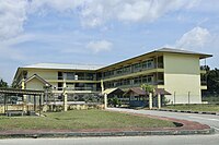
 Government Department Building Complex


.jpg)


References
[edit]- ^ Cohen, Saul Bernard (2008). The Columbia Gazetteer of the World: A to G. Columbia University Press. p. 301. ISBN 978-0-231-14554-1.
- ^ "ANNEX B" (PDF). deps.MoFE.gov.bn. Department of Economic Planning & Statistics. October 2021. Retrieved 23 January 2024.
- ^ a b c d e f Temburong District (PDF). English News Division Information Department Prime Minister’s Office. 2011. pp. 13, 17, 20–21.
- ^ Mohd Yunos, Rozan (2013). SEMINAR UNITED NATIONS GROUP OF EXPERTS ON GEOGRAPHICAL NAMES ASIA, SOUTHEAST DIVISION (PDF). p. 2.
- ^ a b "SEJARAH KAMPUNG". Majlis Perundingan Kampung Belingos. 3 June 2009. Retrieved 10 July 2023.
- ^ "Climate: Bangar". Climate-Data.org. Retrieved 12 August 2020.
- ^ Brunei Darussalam street directory : quick & easy reference maps., Brunei Press Sdn. Bhd., 2014, pp. 188–189 & 198–199, ISBN 9789991732411, OCLC 932264901
- ^ "Temburong District" (PDF). www.information.gov.bn. p. 8. Retrieved 28 February 2018.
- ^ "Jabatan Daerah Temburong, Kementerian Hal Ehwal Dalam Negeri - MUKIM BANGAR". temburong.gov.bn (in Malay). Retrieved 28 February 2018.
- ^ "Buku Poskod Edisi Kedua (Kemaskini 26 Disember 2018)" (PDF). post.gov.bn (in Malay). Brunei Postal Services Department. 26 December 2018. Retrieved 29 July 2021.
- ^ "MUKIM BANGAR". Jabatan Daerah Temburong. Retrieved 10 July 2023.
- ^ "Terminal Jeti Bangar beroperasi » Media Permata Online". Terminal Jeti Bangar beroperasi. 14 March 2018. Retrieved 10 July 2023.
- ^ "RTB unveils new building in Temburong District » Borneo Bulletin Online". RTB unveils new building in Temburong District. 22 March 2022. Retrieved 11 July 2023.
- ^ Inc, IBP (14 May 2016). Brunei Business and Investment Opportunities Yearbook Volume 1 Strategic Information and Opportunities. Lulu.com. p. 182. ISBN 978-1-4387-0627-6.
{{cite book}}:|last=has generic name (help) - ^ "PUJA". www.pujajournal.com. Retrieved 10 July 2023.
- ^ "Jadual kaunter perkhidmatan pos sempena Jubli Emas » Media Permata Online". Jadual kaunter perkhidmatan pos sempena Jubli Emas. 4 October 2017. Retrieved 10 July 2023.
- ^ "Lawatan kenali tugas bomba » Media Permata Online". Lawatan kenali tugas bomba. 5 October 2022. Retrieved 10 July 2023.
- ^ "Berita 2021b - Barang tegahan ditemukan di dalam kenderaan..." www.pelitabrunei.gov.bn. Retrieved 10 July 2023.
- ^ a b "Jabatan Daerah Temburong, Kementerian Hal Ehwal Dalam Negeri - Latar Belakang Jabatan Daerah". www.temburong.gov.bn. Retrieved 10 July 2023.
- ^ "Kem. Pertahanan imarah masjid di Temburong » Media Permata Online". Kem. Pertahanan imarah masjid di Temburong. 11 April 2022. Retrieved 10 July 2023.
- ^ "MINDEF AND RBAF SURAUS GET OFFICIAL NAMES" (PDF). www.mindef.gov.bn. 12 December 2016. p. 35. Retrieved 12 June 2024.
- ^ "Sultan Hassan Secondary School new building". Brunei News Gazette. 6 March 2023. Retrieved 13 July 2023.
- ^ "Call for more Temburong tourism packages". borneo363.rssing.com. Retrieved 10 July 2023.
- ^ "Perpustakaan DBP Seluruh Negara". www.dbplibrary.gov.bn. Retrieved 19 December 2017.
- ^ "Attractions – Green Brunei". Retrieved 10 July 2023.
- ^ "Berita - Umat Islam di Temburong tunaikan Sembahyang..." www.pelitabrunei.gov.bn. Retrieved 10 July 2023.
- ^ Haji.), Metussin bin Haji Baki (Awang (1993). Catatan sejarah masjid-masjid Negara Brunei Darussalam (in Malay). Jabatan Hal Ehwal Syara'iah, Kementerian Hal Ehwal Ugama. p. 366.
- ^ a b "Old Temburong District Office to be turned into museum | The BT Archive". btarchive.org. Retrieved 10 July 2023.
- ^ "bruakal: facts about Brunei". Tumblr. Retrieved 10 July 2023.
- ^ Melayong, Muhammad Hadi bin Muhammad (2009). Memoir seorang negarawan (in Malay). Pusat Sejarah Brunei, Kementerian Kebudayaan, Belia dan Sukan. p. 148. ISBN 978-99917-34-69-9.
- ^ "Jabatan Muzium-Muzium - Monumen dan Tapak-Tapak Arkeologi". www.museums.gov.bn. Retrieved 10 July 2023.
- ^ "Taman Perayaan berwajah baru » Media Permata Online". Taman Perayaan berwajah baru. 29 May 2017. Retrieved 10 July 2023.
External links
[edit]| International | |
|---|---|
| National | |