Barents Sea

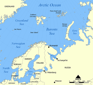
The Barents Sea (Norwegian: Barentshavet, Russian: Баренцево море) is a part of the Arctic Ocean located north of Norway and Russia. It is named after the Dutch navigator Willem Barents. It is a rather deep shelf sea (average depth 230 m), bordered by the shelf edge towards the Norwegian Sea in the west, the island of Svalbard (Norway) in the northwest, and the islands of Franz Josef Land and Novaya Zemlya (Russia) in the northeast and east.
The southern half of the Barents Sea, including the ports of Murmansk (Russia) and Vardø (Norway) remain ice-free year round due to the warm North Atlantic drift. In September, the entire Barents Sea is more or less completely ice-free. Until the Winter War, Finland's territory also reached to the Barents Sea, with the harbor at Petsamo being Finland's only ice-free winter harbor.
There are three main types of water masses in the Barents Sea: Warm, salty Atlantic water (temperature >3°C, salinity>35) from the North Atlantic drift, cold Arctic water (temperature <0°C, salinity<35) from the north, and warm, but not very salty coastal water (temperature >3°C, salinity<34,7). Between the Atlantic and Polar waters, a front called the Polar Front is formed. In the western parts of the sea (close to Bjørnøya), this front is determined by the bottom topography and is therefore relatively sharp and stable from year to year, while in the east (towards Novaya Zemlya), it can be quite diffuse and its position varies a lot between years.
Due to the North Atlantic drift, the Barents Sea has a high biological production compared to other oceans of similar latitude. The spring bloom of phytoplankton can start quite early close to the ice edge, because the fresh water from the melting ice makes up a stable water layer on top of the sea water. The phytoplankton bloom feeds zooplankton such as Calanus finmarchicus, Calanus glacialis, Calanus hyperboreus, Oithona spp., and krill. The zooplankton feeders include young cod, capelin, polar cod, whales and Little Auk. The capelin is a key food for top predators such as the North-East Arctic cod, harp seals, and seabirds such as Common Guillemot and Brunnich's Guillemot. The fisheries of the Barents Sea, in particular the cod fisheries, are of great importance for both Norway and Russia.
During the Cold War, the Soviet Red Banner Northern Fleet used the southern reaches of the Sea as a ballistic missile submarine bastion, a strategy that Russia continues. Nuclear contamination from dumped Russian naval reactors is an environmental concern in the Barents Sea.
Oil exploration in the Barents Sea began in the 1970s. Discoveries were made on both the Russian and Norwegian sides. The first major producing field will be Snøhvit in the Norwegian sector. The largest discovery to date is the Shtokman field in the Russian sector. There is a boundary despute between Norway and Russia, with the Norwegians favouring the Median Line and the Russians favouring a meridian based sector.
External links
- euroarctic.com News service from the Barents region provided by Norwegian Broadcasting Corp (NRK), Swedish Radio (SR) and STBC Murman.
- WWF Barents Sea Ecoregion Learn more about conservation in the Barents Sea.
- Environment, climate change, and history of exploration (Barents' wintering).
