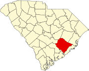
Bethera, South Carolina
Appearance
Bethera, South Carolina | |
|---|---|
| Coordinates: 33°12′06″N 79°47′17″W / 33.20167°N 79.78806°W | |
| Country | United States |
| State | South Carolina |
| Counties | Berkeley |
| Elevation | 49 ft (15 m) |
| Time zone | UTC-5 (Eastern (EST)) |
| • Summer (DST) | UTC-4 (EDT) |
| Area codes | 843, 854 |
| GNIS feature ID | 1246810[1] |
Bethera is an unincorporated community in Berkeley County in the Lowcountry of South Carolina about 40 miles (64 km) north of Charleston. The elevation of the community is 49 feet (15 m)[1]
The name "Bethera" is an amalgamation of the names of two local churches, namely Bethel Baptist and Berea Methodist.[2]
References
- ^ a b "Bethera, South Carolina". Geographic Names Information System. United States Geological Survey, United States Department of the Interior.
- ^ Federal Writers' Project (1941). Palmetto Place Names. Sloane Printing Co. p. 25.


