
Biru County
Biru County
比如县 • འབྲི་རུ་རྫོང་། | |
|---|---|
.png) Location of Biru County (red) within Nagqu City (yellow) and the Tibet Autonomous Region | |
 Biru Location of the seat in Tibet Autonomous Region | |
| Coordinates: 31°46′39″N 93°33′00″E / 31.77750°N 93.55000°E | |
| Country | People's Republic of China |
| Autonomous region | Tibet |
| Prefecture-level city | Nagqu |
| Time zone | UTC+8 (China Standard) |
| Biru County | |||||||||||
|---|---|---|---|---|---|---|---|---|---|---|---|
| Chinese name | |||||||||||
| Simplified Chinese | 比如县 | ||||||||||
| Traditional Chinese | 比如縣 | ||||||||||
| |||||||||||
| Tibetan name | |||||||||||
| Tibetan | འབྲི་རུ་རྫོང་། | ||||||||||
| |||||||||||
Biru County (Tibetan: འབྲི་རུ་རྫོང་།; Chinese: 比如县) is the most populated county within Nagqu of the Tibet Autonomous Region. The name means "female yak". Either of the following pronunciations can be considered correct in Standard Tibetan: [bìru] ~ [pìru] (conventionally written Biru in English) or [ɖìru] ~ [ʈìru] (conventionally Driru).
Geography
Diru/Driru/ Biru lies in the southwest part of the former province of Kham. To its east is Chamdo and to its west Nagchu. Diru/Driru/Biru is located on the Gyalmo Ngulchu River (upper part of Salween River). Diru is bordered by Sog county སོག་རྫོང་། to the northwest and the extreme east of Palbar (Banbar County) དཔལ་འབར་རྫོང་, is also surrounded by Lhari county ལྷ་རི་རྫོང་/ to the south, and extreme north to the Nagchu county.
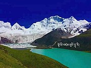
Sepu Kangri is located in the county.
Climate
| Climate data for Biru (1981−2010) | |||||||||||||
|---|---|---|---|---|---|---|---|---|---|---|---|---|---|
| Month | Jan | Feb | Mar | Apr | May | Jun | Jul | Aug | Sep | Oct | Nov | Dec | Year |
| Mean daily maximum °C (°F) | 2.0 (35.6) |
3.9 (39.0) |
7.7 (45.9) |
11.7 (53.1) |
15.7 (60.3) |
18.7 (65.7) |
20.3 (68.5) |
20.2 (68.4) |
17.7 (63.9) |
12.8 (55.0) |
7.1 (44.8) |
3.5 (38.3) |
11.8 (53.2) |
| Mean daily minimum °C (°F) | −13.7 (7.3) |
−10.8 (12.6) |
−6.4 (20.5) |
−2.5 (27.5) |
1.5 (34.7) |
5.5 (41.9) |
7.0 (44.6) |
6.5 (43.7) |
4.2 (39.6) |
−1.2 (29.8) |
−8.3 (17.1) |
−12.8 (9.0) |
−2.6 (27.4) |
| Average precipitation mm (inches) | 6.1 (0.24) |
6.5 (0.26) |
9.3 (0.37) |
16.1 (0.63) |
60.1 (2.37) |
133.1 (5.24) |
122.2 (4.81) |
108.4 (4.27) |
89.8 (3.54) |
31.5 (1.24) |
4.9 (0.19) |
3.8 (0.15) |
591.8 (23.31) |
| Source: National Meteorological Center of CMA[1] | |||||||||||||
Demographics
At the 2009 PRC census, the county's population was 60,179, of whom:
| Name of group | Number | Percentage |
|---|---|---|
| Tibetans | 59,824 | 99.21% |
| Han | 313 | 0.69% |
| Bai | 11 | 0.02% |
| Uyghurs | 9 | 0.02% |
| Others | 22 | 0.05% |
Gallery
-
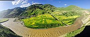
 Biru Town from southbank of Gyalmo Ngulchu
 -
 Biru Town from the hill to the north
 -
 Tsachu/Caqu village
 -
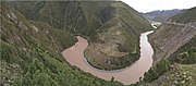 A meander of the river in Biru from the north bank
 -
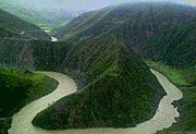 Same meander of the river from the south bank
 -
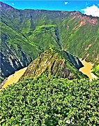 View of a meander from the top
 -
-
 A monastery stupa in Biru
 -
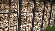 The Biru Skull Wall, a local funerary practice
 -


References
- ^ 1981年-2010年(比如)月平均气温和降水 (in Simplified Chinese). National Meteorological Center of CMA. Retrieved 25 November 2022.
| District |  | |
|---|---|---|
| Counties | ||
| Towns and villages |
| |
| Geography | ||
| Sciences | ||
This Nagqu Prefecture, Tibet location article is a stub. You can help Wikipedia by expanding it. |