
Cadier en Keer
Cadier en Keer | |
|---|---|
Village | |
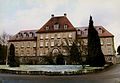
 Blankenberg Castle at Cadier en Keer | |
 Cadier en Keer Location in the Netherlands  Cadier en Keer Location in the province of Limburg in the Netherlands | |
| Coordinates: 50°49′38″N 5°46′10″E / 50.82722°N 5.76944°E | |
| Country | Netherlands |
| Province | Limburg |
| Municipality | Eijsden-Margraten |
| Area | |
| • Total | 1.55 km2 (0.60 sq mi) |
| Elevation | 127 m (417 ft) |
| Population (2021)[1] | |
| • Total | 3,205 |
| • Density | 2,100/km2 (5,400/sq mi) |
| Time zone | UTC+1 (CET) |
| • Summer (DST) | UTC+2 (CEST) |
| Postal code | 6267[1] |
| Dialing code | 043 |
| Major roads | N278 |
Cadier en Keer (Limburgish: Keer) is a village in the Dutch province of Limburg. It is a part of the municipality of Eijsden-Margraten, and lies about 5 km east of Maastricht.
History[edit]
The village was first mentioned in 1266 as Cadirs. It has a double name, but it has always been a single village. The northern side of the road fell under Maastricht as Keer while the southern side fell under Dalhem as Cadier.[3] In 1662, the village became part of the Dutch Republic.[4]
The Catholic Exaltation Church is an aisleless church with detached tower. The tower has 12th century elements. The church was built between 1957 and 1958 in traditional style.[5]
Blankenberg Castle was first mentioned in 1371. The current building dates from 1825. In 1904, it became a monastery of the French fraternity of Saint Blaise. The mission house was built in 1891. The originally buildings burnt down in 1954. It currently houses the Africa museum.[5]
Cadier was a separate municipality until 1828. Cadier en Keer was a separate municipality between 1828 and 1982, when it was merged with Margraten.[6] Cadier was home to 215 people in 1840 and Keer had 335 inhabitants. In 2011, the village became part of the municipality of Eijsden-Margraten.[4]
Gallery[edit]
-
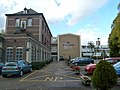
 Gerlach building at Cadier en Keer
 -
 Mission house and Africa museum
 -
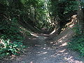 Forest road


References[edit]
- ^ a b c "Kerncijfers wijken en buurten 2021". Central Bureau of Statistics. Retrieved 24 April 2022.
- ^ "Postcodetool for 6267NA". Actueel Hoogtebestand Nederland (in Dutch). Het Waterschapshuis. Retrieved 24 April 2022.
- ^ "Cadier en Keer - (geografische naam)". Etymologiebank (in Dutch). Retrieved 24 April 2022.
- ^ a b "Cadier en Keer". Plaatsengids (in Dutch). Retrieved 24 April 2022.
- ^ a b Sabine Broekhoven, & Ronald Stenvert (2003). Cadier en Keer (in Dutch). Zwolle: Waanders. ISBN 90 400 9623 6. Retrieved 23 April 2022.
- ^ Ad van der Meer and Onno Boonstra, Repertorium van Nederlandse gemeenten, KNAW, 2011.
External links[edit]
 Media related to Cadier en Keer at Wikimedia Commons
| International | |
|---|---|
| National | |