Codalet
Appearance
Codalet | |
|---|---|
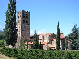
 The Saint-Michel-de-Cuxa Abbey, in Codalet | |
| Coordinates: 42°36′40″N 2°25′02″E / 42.6111°N 2.4172°E | |
| Country | France |
| Region | Occitania |
| Department | Pyrénées-Orientales |
| Arrondissement | Prades |
| Canton | Les Pyrénées catalanes |
| Government | |
| • Mayor (2020–2026) | Michel Llanas[1] |
| Area 1 | 2.78 km2 (1.07 sq mi) |
| Population (2021)[2] | 357 |
| • Density | 130/km2 (330/sq mi) |
| Time zone | UTC+01:00 (CET) |
| • Summer (DST) | UTC+02:00 (CEST) |
| INSEE/Postal code | 66052 /66500 |
| Elevation | 347–680 m (1,138–2,231 ft) (avg. 350 m or 1,150 ft) |
| 1 French Land Register data, which excludes lakes, ponds, glaciers > 1 km2 (0.386 sq mi or 247 acres) and river estuaries. | |
Codalet (French pronunciation: [kodalɛt] ) is a commune in the Pyrénées-Orientales department in southern France.[3]
It is very small with only a few streets but has much character. There are no shops but there is a little park with a boules court and soccer goal as well as a river running through it. Codalet has an annual garage sale for the May Day celebrations which takes place in the Codalet square. There is also the annual Flama del Canigou festival in the Prades Park.[citation needed]
Geography
Localisation
Codalet is located in the canton of Les Pyrénées catalanes and in the arrondissement of Prades.

Population
Graphs are unavailable due to technical issues. There is more info on Phabricator and on MediaWiki.org. |
| Year | Pop. | ±% p.a. |
|---|---|---|
| 1968 | 252 | — |
| 1975 | 316 | +3.29% |
| 1982 | 311 | −0.23% |
| 1990 | 329 | +0.71% |
| 1999 | 359 | +0.97% |
| 2007 | 389 | +1.01% |
| 2012 | 360 | −1.54% |
| 2017 | 386 | +1.40% |
| Source: INSEE[4] | ||
Sites of interest
Saint-Michel-de-Cuxa abbey is located on the territory of the commune.
See also
References
- ^ "Répertoire national des élus: les maires". data.gouv.fr, Plateforme ouverte des données publiques françaises (in French). 2 December 2020.
- ^ "Populations légales 2021" (in French). The National Institute of Statistics and Economic Studies. 28 December 2023.
- ^ INSEE commune file
- ^ Population en historique depuis 1968, INSEE
Wikimedia Commons has media related to Codalet.


