
Coyote Buttes

Coyote Buttes is a section of the Paria Canyon-Vermilion Cliffs Wilderness managed by the Bureau of Land Management (BLM), spanning extreme south-central Utah and north-central Arizona, south of US 89 halfway between Kanab, Utah and Page, Arizona. It is divided into two areas: Coyote Buttes North and Coyote Buttes South. Visiting either of the Coyote Buttes areas requires purchasing a hiking permit.
The Coyote Buttes area is an exposure of cross-bedded aeolian Jurassic Navajo Sandstone.[1] The variable coloration of the sandstones is a result of various iron oxide pigments within the layers. A dinosaur trackway or trample surface is found in the area and provides evidence of a variety of dinosaurs.[1] The area includes dramatic swirling erosional rock formations such as The Wave.
The Wave and Buckskin Gulch share the Wire Pass Trailhead on House Rock Valley Road.
Dinosaur trackway
[edit]The dinosaur trackway within the area is a site of 0.75 acres (3,000 m2) that has densely packed dinosaur footprints within the area. The trackway contains more than 1,000 footprints which were made approximately 190 million years ago.[2] Tracks of three genera of Eubrontes, Anchisauripus and Grallator are present along with a Sauropodomorph that has not been identified.[1]
Gallery
[edit]-
 Coyote Buttes
 -
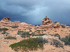 Coyote Buttes
 -
 The Wave
 -
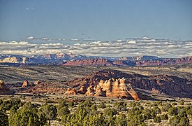 Looking north past the teepees, in Coyote Buttes South


References
[edit]- ^ a b c Seiler, W. M. (2008), Jurassic Navajo sandstone of Coyote Buttes, Utah/Arizona: coloration and diagenetic history, preservation of a dinosaur trample surface, and terrestrial analogs to Mars (MS Thesis), The University of Utah
- ^ "Scientists Discover 'Dinosaur Dance Floor'". The Washington Post. October 22, 2008. p. KidsPost.
External links
[edit]- "Coyote Buttes". Geographic Names Information System. United States Geological Survey, United States Department of the Interior.
- "Bureau of Land Management website". Archived from the original on 2012-04-13., with information on hiking permits
- "The Wave (Coyote Buttes)". SummitPost.org.
- Buttes of Arizona
- Buttes of the United States
- Mountains of Utah
- Rock formations of Utah
- Rock formations of Arizona
- Landforms of Coconino County, Arizona
- Landforms of Kane County, Utah
- Sandstone in the United States
- Jurassic Arizona
- Jurassic geology of Utah
- Kanab, Utah
- Colorado Plateau
- Bureau of Land Management areas in Arizona
- Bureau of Land Management areas in Utah
- Protected areas of Coconino County, Arizona
- Protected areas of Kane County, Utah