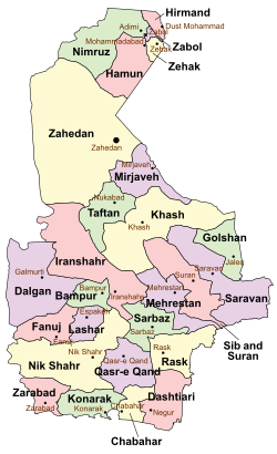
Dashtiari County
Appearance
Dashtiari County
شهرستان دشتیاری | |
|---|---|
 Location of Dashtiari County in Sistan and Baluchestan province | |
 Location of Sistan and Baluchestan province in Iran | |
| Coordinates: 25°37′N 61°24′E / 25.617°N 61.400°E | |
| Country | |
| Province | Sistan and Baluchestan |
| Capital | Negur |
| Districts | 1 (2006) |
| Population (2006) | |
| • Total | 57,813 |
| Time zone | UTC+3:30 (IRST) |
| • Summer (DST) | UTC+4:30 (IRDT) |
Dashtiari County (Template:Lang-fa) is located in Sistan and Baluchestan province, Iran. The capital of the county is Negur. At the 2006 census, the county's population was 57,813, in 11,196 families.[1] It was separated from Chabahar County in 2018.[2]
Administrative divisions
| Administrative Divisions1 | Pop. |
|---|---|
| Dashtiari District | 57,813 |
| Bahu Kalat Rural District | 24,478 |
| Negur Rural District | 17,425 |
| Sand-e Mir Suiyan Rural District | 12,151 |
| Negur City | 3,759 |
| Total Dashtiari County | 57,813 |
1 As a part of Chabahar County
References
- ^ a b "Census of the Islamic Republic of Iran, 1385 (2006)" (Excel). Statistical Center of Iran. Archived from the original on 2011-09-20.
- ^ "تصویب ایجاد دهستان، بخش و شهرستان در سیستان و بلوچستان". cabinetoffice.ir. Retrieved 11 March 2020.
Wikimedia Commons has media related to Dashtiari County.

