
Dee Cliffs
| Site of Special Scientific Interest | |
.jpg) | |
 Location within Merseyside | |
| Location | Merseyside |
|---|---|
| Grid reference | SJ238832 |
| Coordinates | 53°20′35″N 3°09′04″W / 53.343°N 3.151°W |
| Interest | Geological |
| Area | 14.39 hectares, 35.55 acres (143,900 m2) |
| Notification | 1979 / 1983 |
| Natural England website | |
Dee Cliffs (SSSI) is an area of cliffs on the eastern side of the Dee Estuary and to the west of Thurstaston on the Wirral Peninsula, England.
The area contains the best known example of clay cliff and bank habitat in Merseyside. The area also has some marl pits, which have a rich flora and fauna and an area of herb-rich neutral grassland.
Gallery
-
 Cliff face at Thurstaston
 -
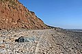
 Coastal erosion
 -
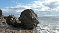
 Boulder deposition
 -
 Boulder clay at Thurstaston
.jpg)

.jpg)

References
- "Dee Cliffs citation sheet" (PDF). English Nature. Archived from the original (PDF) on 4 March 2016.
This article about a Site of Special Scientific Interest in England is a stub. You can help Wikipedia by expanding it. |
This Merseyside location article is a stub. You can help Wikipedia by expanding it. |