
Dysert O'Dea Monastery
Dysert O'Dea Church near Corofin in County Clare, Ireland stands on the site of an early Christian monastery which was founded by St. Tola, who died in about A.D. 735, although most of the present buildings are from the 12th century.
Architecture

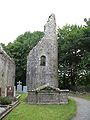
The Dysert O'Dea monastic site is home to the Dysert O'Dea Church and the remains of a round tower. The church contains many long forgotten graves with some lovely crosses. The most interesting parts of the church are the east window, which is made up of three tall arches, and the beautifully carved doorway, made of four arches. The most significant arch is the first one, which is made of many faces (humans, dogs, and birds). The other three, inner, arches are carved with different patterns.
The round tower survives as a five metre stump. The doorway is present near the top of the stump and there are two arrow-slit windows at ground level.
Nearby
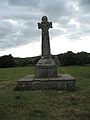
This monastic site is part of the Dysert O'Dea Archaeological Trail. There are many more historical sites in the immediate vicinity including O'Dea Castle, St. Tola's high cross (with a carving of Christ being crucified), two ring forts, the remains of a fulacht fiadh, and the ruins of a stone Victorian house dating from 1861.
Gallery
-
 Doorway
 -
 Dysert round tower
 -
 St. Tola's high coss
 -
 Victorian ruins


See also
References
- O'Dea: Ua Deághaidh: The Story of a Rebel Clan, by Risteárd Ua Cróinín (Richard Cronin), Ballinakella Press, Whitegate, Co. Clare, Ireland, 1992. ISBN 0-946538-07-7.
52°54′33″N 9°04′06″W / 52.909195°N 9.068444°W
- Christian monasteries in the Republic of Ireland
- Buildings and structures in County Clare
- Religion in County Clare
- Ruins in the Republic of Ireland
- Christian monasteries established in the 8th century
- National Monuments in County Clare
- European church stubs
- Irish building and structure stubs
- Christian monastery stubs