Elbe–Lübeck Canal
| Elbe–Lübeck Canal | |
|---|---|
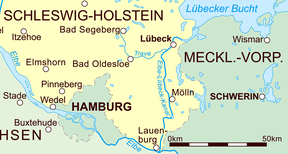
 The canal in eastern Schleswig-Holstein | |
 | |
| Specifications | |
| Length | 40 miles (64 km) |
| Locks | 7 |
| History | |
| Construction began | 1895 |
| Date completed | 1900 |
| Geography | |
| Start point | Lauenburg (Elbe) |
| End point | Lübeck (Trave) |
The Elbe–Lübeck Canal () (also known as the Elbe–Trave Canal) is an artificial waterway in eastern Schleswig-Holstein, Germany. It connects the rivers Elbe and Trave, creating an inland water route across the drainage divide from the North Sea to the Baltic Sea. The canal includes seven locks and runs for a length of 64 kilometres (40 mi) between the cities of Lübeck in the north and Lauenburg in the south by way of the Mölln lakes.[1] The modern canal was built in the 1890s to replace the Stecknitz Canal, a medieval watercourse linking the same two rivers.[2]
Preceding canal
The older Stecknitz Canal had first connected Lauenburg and Lübeck on the Old Salt Route by linking the tiny rivers Stecknitz (a tributary of the Trave) and Delvenau (a tributary of the Elbe). Built between 1391 and 1398, the Stecknitz Canal was the first European summit-level canal and one of the earliest artificial waterways in Europe.[3]
History

After German unification in the late nineteenth century, there was a burst of canal-building within the new German Empire.[4] The Stecknitz Canal had been in service for centuries, but newer vessels demanded deeper and wider canals, and modern engineering offered the possibility of rebuilding and enlarging the venerable waterway. In 1893 the German government closed the Stecknitz Canal to barge traffic, and in 1895 construction began on a widened and straightened waterway which includes some of the old canal's watercourse.[5][6] The new Elbe–Lübeck Canal was inaugurated by German Emperor Wilhelm II and opened to shipping traffic in 1900.[7] Today it continues to carry substantial freight traffic, as well as offering a scenic route for pleasure craft.[8]
Technology

The canal passes through two locks ascending from the Elbe to the canal's highest point and five locks descending from the high point to the Trave. Each lock was built with an interior length of 80 metres (260 ft) and an interior width of 12 metres (39 ft).[8]
References
- ^ "Elbe–Trave Canal". Great Soviet Encyclopedia (3rd ed.). 1979. Retrieved 4 October 2016.
- ^ Clarke, Michael. "Elbe–Lübeck Canal". Encyclopædia Britannica. Retrieved 26 September 2016.
- ^ Zumerchik, John; Danver, Steven Laurence (2010). Seas and Waterways of the World: An Encyclopedia of History, Uses, and Issues. Vol. 1. ABC-CLIO. pp. 118, 121. ISBN 9781851097111. Retrieved 27 May 2016.
- ^ Pohl, R. "History of Hydraulic Engineering" (PDF). Dresden University of Technology. Retrieved 17 October 2016.
- ^ Clarke, Michael. "Stecknitz Canal". Encyclopædia Britannica. Retrieved 27 May 2016.
- ^ "Inland Navigation in Germany". The Geographical Journal. 5. Royal Geographical Society: 379. 1895. Retrieved 28 September 2016.
- ^ "ELBE-TRAVE CANAL OPENED.; Kaiser Makes a Speech -- Description of the Undertaking". The New York Times. 17 June 1900. Retrieved 4 October 2016.
- ^ a b "The new Lauenburg lock on the Elbe-Luebeck Canal (ELC) at km 60.15" (PDF). Wasserstraßen- und Schifffahrtsamt Lauenburg. Archived from the original (PDF) on 12 January 2017. Retrieved 10 October 2016.
External links
 Media related to Elbe-Lübeck Canal at Wikimedia Commons
