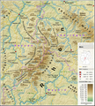
File:Taunus - Deutsche Mittelgebirge, Serie A-de.png
Appearance

Size of this preview: 800 × 522 pixels. Other resolutions: 320 × 209 pixels | 640 × 417 pixels | 1,024 × 668 pixels | 1,280 × 835 pixels | 2,300 × 1,500 pixels.
Original file (2,300 × 1,500 pixels, file size: 5.05 MB, MIME type: image/png)
File history
Click on a date/time to view the file as it appeared at that time.
| Date/Time | Thumbnail | Dimensions | User | Comment | |
|---|---|---|---|---|---|
| current | 23:16, 12 January 2017 |  | 2,300 × 1,500 (5.05 MB) | Thoroe | City size fixes |
| 10:09, 5 January 2017 |  | 2,300 × 1,500 (5.05 MB) | Thoroe | minor additions | |
| 22:59, 4 January 2017 |  | 2,300 × 1,500 (5.05 MB) | Thoroe | some fixes | |
| 11:00, 4 January 2017 |  | 2,300 × 1,500 (5.03 MB) | Thoroe | {{Information |Description ={{en|1=Topographic map of the Taunus}} {{de|1=Topografische Karte des Taunus}} |Source ={{Own using}} *[http://gmt.soest.hawaii.edu Generic Mapping Tools (GMT)] with [http://dds.cr.us... |
File usage
The following 8 pages use this file:
Global file usage
The following other wikis use this file:
- Usage on bg.wikipedia.org
- Usage on br.wikipedia.org
- Usage on de.wikipedia.org
- Usage on en.wikivoyage.org
- Usage on eo.wikipedia.org
- Usage on es.wikipedia.org
- Usage on fa.wikipedia.org
- Usage on fr.wikipedia.org
- Usage on fy.wikipedia.org
- Usage on li.wikipedia.org
- Usage on nl.wikipedia.org
- Usage on no.wikipedia.org
- Usage on pt.wikipedia.org
- Usage on sw.wikipedia.org
- Usage on www.wikidata.org


