
File talk:Roman Empire 125.svg
| Dacia NA‑class (inactive) | |||||||
| |||||||
Missing Section[edit]
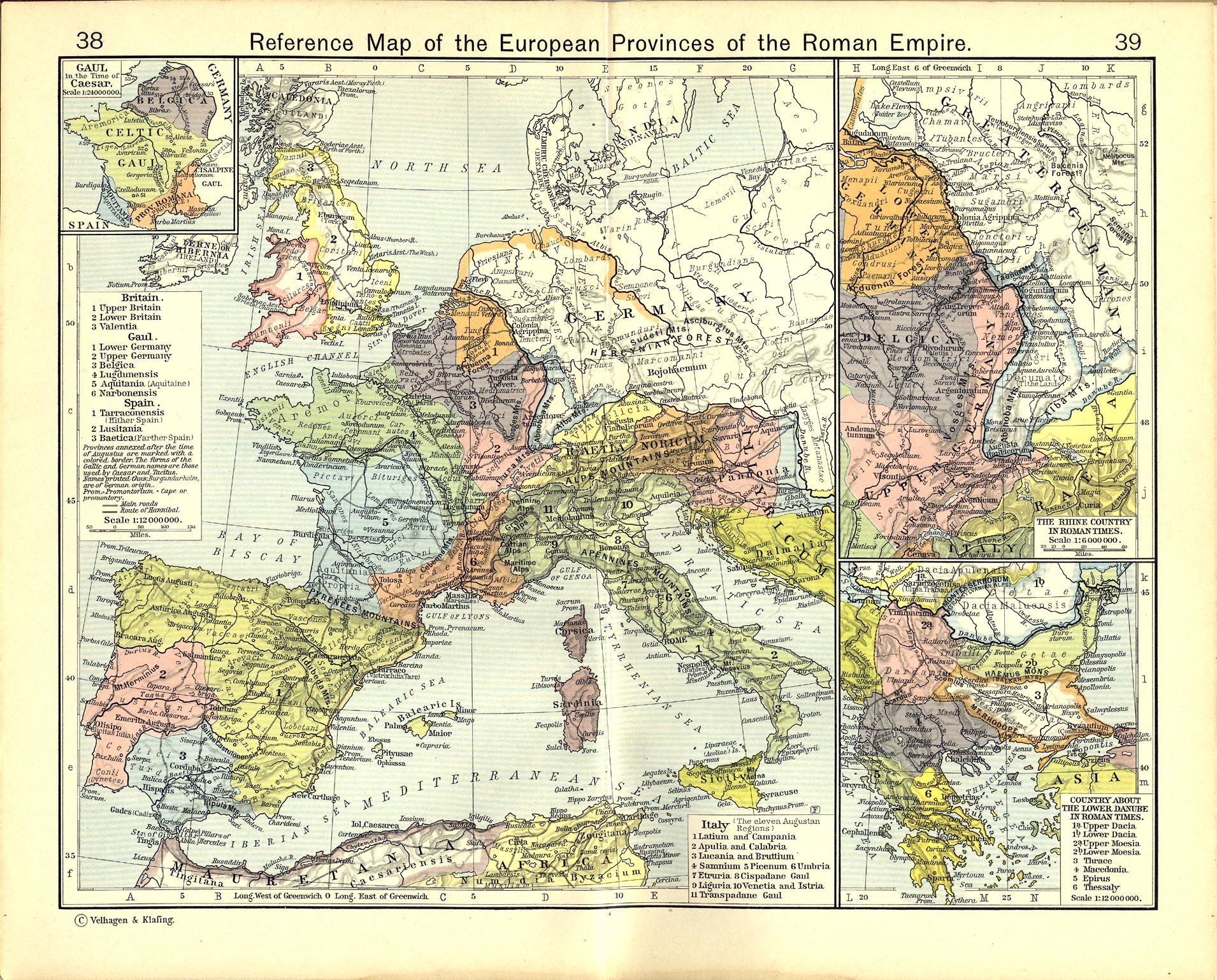
Soory, but this map is WRONG. Lugii were "the most powerfull nation" (Tacitus, Ptolemy etc.), so why ther're in south Poland? There were some celtic tribes... And they aren't "Vandalini" - it was Burgundiones and another Eastern Germans name ;) —Preceding unsigned comment added by 83.1.16.51 (talk) 10:40, 29 July 2009 (UTC)
Placing "sitones?" in central-northern Sweden is incorrect. And Estonia to the east of Sweden, they should be called Estonians, as Estonian tribes inhabited the area already back then. I can give citations if necessary. I also think think that placing something called "Fenni" into middle of modern Poland or Western Ukraine is also incorrect. This name probably refers to proto-finns who inhabited the area what is now roughly the modern part of European part of Russia. Therefore the name "Fenni" should be replaced with "Finns".
- I am responding to this, as I acted as historical advisor to the map's creator, Andrei Nacu. The location of barbarian tribes on this map is based on contemporary sources: Tacitus's Germania (written ca. AD 100) and Ptolemy's Geographia (ca. AD 130). In addition, all entries are in accordance with Barrington's Atlas (2000), the most authoritative and up-to-date classical atlas. All the names on the map are those used by the Romans of the time, so we cannot enter "Estonians" or "Finns", as these are modern terms. It is also worth noting that there is a great deal of uncertainty about the location and ethno-linguistic affiliation of those peoples that were furthest from the Roman world, precisely because the classical authors themselves only had vague notions about them. So let's not say that an entry is "correct" or "incorrect", but rather that it's "likely" or "unlikely". That is why I have placed question marks after SITONES and FENNI. Also you should be very cautious about identifying ancient ethnic groups with modern ones. That modern Estonians are descended, to some degree, from the AD 125 inhabitants of the region now known as Estonia is likely, though not certain. But to say that those early inhabitants called themselves Estonians and spoke a Finnoid language is impossible to prove, as they did not leave a written record. They could just as easily have spoken a Balto-Slavic language or something else again.
Regarding your specific points:
- SITONES? in central Sweden is based on the only mention of this people, Tacitus Germania 45: This states that the Sitones bordered on the Suiones, who are generally identified as the inhabitants of what is now known as Sweden. This places the Sitones in Sweden also, especially as Scandinavia was at that time believed to be an island. It is possible that the name of the central Swedish region known historically as Sigtuna is derived from this tribal name.
- SITONES? in Estonia is based on the same entry in Barrington's (which is based on academic references). I don't see your problem with this, since Sitones could easily be the Latinised form of "Estonians" and I have shown them as probably Finno-Ugric speakers.
- FENNI? in the upper Vistula region is based on Ptolemy. Ptolemy actually gives two locations for what he called the Phinnoi: one in northern Scandinavia "island", which have generally been identified with the modern Sami (Lapps): these cannot be shown, as the map does not cover N Scandinavia. The other location in Ptolemy is described as S of the Goths, who are known at the time to have resided in the middle Vistula area. (Geographia III.5)
- The other FENNI? rubric is not in Ukraine as you say, but in Belarus/Gulf of Finland Russia. Since this where you say they should be, I don't see the objection. This entry is based on Tacitus G.46 that could be interpreted as saying that the Fenni were at the opposite end of the Eurasian landmass as the Peucini branch of the Bastarnae group. Since the Peucini inhabited the NE shore of the Black Sea, this would indicate a Fenni location somewhere near the Gulf of Finland. Despite the similarity of the "Fenni" with "Finns", it is uncertain that they were the same people.
If you are interested in more information, I had a very comprehensive discussion of these same issues with another user a while ago, which you can access on Andrei Nacu's user discussion history (around february of this year). PS: In future, please sign all your messages. Who are you? EraNavigator (talk) 10:05, 28 April 2009 (UTC)
Map is incorrect[edit]
In the future, when drawing a map try to use ancient map sources instead of your imagination. http://ancienthistory.about.com/od/europe/a/europemaps.htm http://ancienthistory.about.com/od/maps/ss/mapsindex.htm This is embarrassing. 99.236.221.124 (talk) 22:10, 7 June 2010 (UTC)
Incorrect Map!!![edit]
Very Very Very disappointed that Wikipedia would mislead the public with an Ancient Map made by an amateur who produces many many errors.
www.lib.utexas.edu/maps/historical/shepherd_1911/shepherd-c-038-039.jpg
www.hadrians.com/images/graphics/rome/maps/roman_empire_under_hadrian_116_ad.jpg
There are many correct ancient maps available. Wikipedia is a thorough pain in the you know what when it comes to subjects as History, Geography and Religion. The ignorance of religion shines through. That's not what is needed. What a propaganda machine of historic errors. Very sad indeed.
PhaiakianLandIsScandinavia (talk) 06:08, 21 June 2010 (UTC)
- Actually this comment and the one above are much more disappointing than this map. This map is rather laudable and valuable effort for Wikipedia/Wikimedia. The notion that 50-100 year old maps of the roman empire published in books are error free and accurately reflect the latest knowledge and hence are automatically superior to this one is a bit ridiculous. Moreover errors and inaccuracies in old maps cannot be corrected by us, whereas errors in this map can easily be corrected by us. So instead of making vague general complaints with references to outdated material, it would be much more helpful if you list actual and concrete errors in this map, so that the author or somebody else can fix them.--Kmhkmh (talk) 14:19, 27 November 2010 (UTC)
Pamphylia[edit]
It must be "Pamphylia"! Böri (talk) 12:17, 9 November 2010 (UTC)
Dacians as Slavs, Costoboci uncertain on the Roman Empire Map?[edit]
Dacians are marked with the same color as Slavs which is completely incorrect and unfortunate. While Costoboci and Carpi, considered by most historians as Dacian, are in a blue/uncertain color. While Bastarnae who are a Celtic-Germanic mix with possible Dacian elements is marked as Germanic for sure. This is raising serious questions about the map and its neutrality. I suggest at least a distinct Dacian color and section in the legend. A similar version of the map is here: commons:File:Roman Empire 125.png. --Codrin.B (talk) 21:21, 5 January 2011 (UTC)
- Read what happen here. Look at the Changes to Empire 125 map section of the talk, which was since removed, I assume in good faith. See also this newer version of the file as well, which was moved to png format, losing the history of changes about the same time (November 19-20, 2010). Please also check the corresponding commons versions. This talk is also very relevant. And another broader point is this: Due to the hard work of the author, this map is used by a LOT of pages, and significant changes to it should involve more discussions and scrutiny from now on. It can no longer be updated with radical changes without impacting other articles. Otherwise it becomes some sort of Trojan horse, pushing incorrect information to many articles in one shot. --Codrin.B (talk) 03:14, 7 January 2011 (UTC)