
Gaw Yin Gyi Island
Native name: ဂေါ်ရင်ဂျီကျွန်း | |
|---|---|
 | |
 Gaw Yin Gyi Island Location in Myanmar | |
| Geography | |
| Location | Ngayokekaung sub-township, Pathein District, Ayeyarwady Region, Myanmar |
| Coordinates | 16°31′59″N 94°14′33″E / 16.5331°N 94.2425°E |
Gaw Yin Gyi Island (Burmese: ဂေါ်ရင်ဂျီကျွန်း) is an island in Ayeyarwady Region in South West Myanmar. It is located near Nanthapu village, Ngayokekaung sub-township, Pathein District of Myanmar. It is a tourist destination due to its beautiful rock formation and reefs.
History
This section is empty. You can help by adding to it. (March 2016) |
Geography
There are some rocky islets which also have beautiful and unspoiled beaches .
Rock Climbing
There is a rock climbing and bouldering site. Deep water soloing is available.
Transportation
While buses and cars operate, it is also reached by boat.
Gallery
-
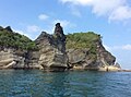 Deep water solo
 -
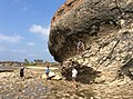 Rock climb


References
This Ayeyarwady Region location article is a stub. You can help Wikipedia by expanding it. |