
Yasser Arafat International Airport
Yasser Arafat International Airport مطار ياسر عرفات الدولي | |||||||||||
|---|---|---|---|---|---|---|---|---|---|---|---|
 The airport in 2005 | |||||||||||
| Summary | |||||||||||
| Airport type | Defunct | ||||||||||
| Operator | Palestinian Civil Aviation Authority and Israeli government | ||||||||||
| Location | Gaza Strip | ||||||||||
| Opened | 24 November 1998 | ||||||||||
| Closed | 2001 | ||||||||||
| Elevation AMSL | 98 m / 320 ft | ||||||||||
| Coordinates | 31°14′47″N 34°16′34″E / 31.24639°N 34.27611°E | ||||||||||
| Runways | |||||||||||
| |||||||||||
Yasser Arafat International Airport (Arabic: مطار ياسر عرفات الدولي Maṭār Yāsir 'Arafāt ad-Dawli) (IATA: GZA, ICAO: LVGZ),[1] formerly Gaza International Airport and Dahaniya International Airport, was located in the Gaza Strip, between Rafah and Dahaniya, close to the Egyptian border. The facility opened on 24 November 1998, and all passenger flights ceased in February 2001, during the Second Intifada. Israel bombed the radar station and control tower on 4 December 2001 and bulldozers cut the runway on 10 January 2002, rendering the airport inoperable.
History
The airport was operated by the Palestinian Civil Aviation Authority and Israeli government. It was able to handle 700,000 passengers per year, and its total area was 450 hectares (1,100 acres). The airfield served as the base of Palestinian Airlines until it was closed to passenger traffic.[2][3]
The construction of the airport was provided for in the Oslo II Agreement of 1995. It was built with funding from Japan, Egypt, Saudi Arabia, Spain, and Germany. It was designed by Moroccan architects (modeled after Casablanca airport) and engineers funded by Morocco's King Hassan II. The total cost was $86 million and it was built by Usama Hassan Elkhoudary (El-Khoudary for engineering and contracting). After a year of construction, it opened on 24 November 1998; attendees at the opening ceremony included Yasser Arafat and US President Bill Clinton. At the time, the opening of the airport was described as evidence of progress toward Palestinian statehood.[4][5] The presence of Israelis was restricted to checking passports and bags.[6]
The first commercial flight to depart from the Gaza airport was a Palestinian Airlines flight to Amman on 5 December 1998.[7] Over the following year, the airport received 90,000 passengers and processed more than 100 tons of cargo. By mid-2000, a handful of foreign carriers, including Royal Air Maroc and Egyptair, had introduced flights to Gaza as well.[8]
Second Intifada
The Second Intifada broke out in September 2000, leading to the closure of the airport the following month.[9] Israel alternated between reopening and shutting down the airport over the next several months before finally prohibiting all commercial air traffic on 13 February 2001; from then on, only Arafat's private aircraft were allowed to use the airfield.[10][11] Airstrikes destroyed the radar station and control tower on 4 December 2001 and bulldozers cut the runway on 10 January 2002.[12][13][14] Its destruction left Gush Katif Airport as the only serviceable runway in Gaza, until it was abandoned in 2004. The closest public airports in the area are Ben Gurion Airport in Israel and El Arish Airport in Egypt. From 2001 to 2006, airport personnel still staffed the ticket counters and baggage areas,[14] though no aircraft flew into or out of the airport during that period.
In March 2002, the International Civil Aviation Organization (ICAO) strongly condemned Israel for the attack on the airport, which it deemed a violation of the Convention for the Suppression of Unlawful Acts against the Safety of Civil Aviation (Montreal Convention, 1971). The ICAO also urged Israel to take measures to restore the facility to allow its reopening.[12]
On 15 November 2005, after the end of the intifada and the Israeli unilateral withdrawal from the Gaza Strip, Israel and the Palestinian Authority (PA) signed the Agreement on Movement and Access that provided: "The parties agreed on the importance of the [Yasser Arafat International] airport. Discussions will continue on the issues of security arrangements, construction and operation."[15]
Hamas rule in Gaza Strip
The Agreement of 2005 became moot after Hamas formed the Government in the Palestinian Authority (PA) on 29 March 2006, and Israel and the Quartet on the Middle East imposed sanctions against the PA under Hamas and all dialogue with the Hamas PA government ceased. The sanctions were strengthened in the Gaza Strip after the Hamas takeover of the Gaza Strip in June 2007. Since March 2006, no discussions have taken place between Israel and the Hamas government in the Gaza Strip, including in relation to the airport.
Since its closure, thieves have stripped the site of valuable equipment including radars.[6]
Gallery
-
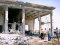
 Damaged building, May 2002
 -
 Yasser Arafat International Airport
 -
 2008 satellite photo of the runway


References
- ^ "Codes of Gaza - Yaser Arafat International Airport in Gaza City, Palestine (PS)". AirportsBase. 2021. Archived from the original on 24 June 2021. Retrieved 16 June 2021.
- ^ "Israelis anxious over Gaza airport". Airline Business. 31 December 1998. Archived from the original on 17 October 2023. Retrieved 27 May 2021.
- ^ Trounson, Rebecca (19 November 1998). "Palestinians Gear Up for Opening of Gaza Airport". Los Angeles Times. ProQuest 421330007.
- ^ Palestinians cheer airport as first step to statehood, Associated Press, 25 November 1998.
- ^ A Political Chronology of the Middle East. Europa Publications. 2006. p. 186.
- ^ a b "20 years after its opening, destroyed Gaza airport embodies grounded peace hopes". Archived from the original on 13 May 2021. Retrieved 4 May 2021.
- ^ Greenberg, Joel (7 December 1998). "A Plane and Patriotism Take Flight in Gaza". The New York Times. Archived from the original on 24 April 2023. Retrieved 27 May 2021.
- ^ Luxner, Larry (8 May 2000). "Palestinians plan cargo terminal at Gaza airport". The Journal of Commerce. Archived from the original on 31 October 2021. Retrieved 27 May 2021.
- ^ "Airport closure keeps Palestinian on the ground". Flight International. 4 December 2000. Archived from the original on 17 October 2023. Retrieved 27 May 2021.
- ^ "Gaza Airport Reopened After Three-Week Closure". Xinhua News Agency. 1 December 2000. ProQuest 453885682.
- ^ Martin, Susan Taylor (25 November 2001). "A Day in Gaza". Tampa Bay Times. ProQuest 263654912.
- ^ a b "ICAO Council adopts resolution strongly condemning the destruction of Gaza International Airport" (PDF). ICAO. 13 March 2002. Archived from the original (PDF) on 22 February 2014.
- ^ Grounded in Gaza, but hoping to fly again Archived 1 December 2019 at the Wayback Machine, NBC News, 19 May 2005
- ^ a b Years of delays at Gaza airport Archived 8 March 2006 at the Wayback Machine, Alan Johnston, BBC News, 15 April 2005
- ^ Agreed documents by Israel and Palestinians on Movement and Access from and to Gaza Archived 15 December 2019 at the Wayback Machine. "Agreement on Movement and Access" and "Agreed Principles for Rafah Crossing", 15 November 2005
External links
 Media related to Yasser Arafat International Airport at Wikimedia Commons