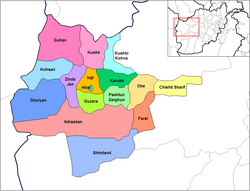
Ghurian
Ghurian
Ghoryan, غوريان | |
|---|---|
 | |
| Coordinates: 34°20′24″N 61°28′12″E / 34.34000°N 61.47000°E | |
| Country | |
| Province | Herat Province |
| Elevation | 2,590 ft (790 m) |
| Population | |
| • Total | 54,000 |
| Time zone | UTC+4:30 |
Ghurian (غوريان; Ghūrīān, Ghoryan, Ġūrīān) is a city and the administrative center of Ghurian District in Herat Province, Afghanistan. It is 790 m high with a population of more than 54,000 people.[1] It is situated south of the Hari River along the Mashhad-Herat highway at 34°20′N 61°28′E / 34.34°N 61.47°E. There is a local TV station and a health center. Ghurian is close to the old city of Pushang.[2]
See also
Notes
- ^ ""Ġūrīān" World Gazetteer". Archived from the original on 2011-05-22.
{{cite web}}: Unknown parameter|deadurl=ignored (|url-status=suggested) (help) - ^ C. EDMUND BOSWORTH, FŪŠANJ, Encyclopedia Iranica

