Gorontalo (city)
Gorontalo | |
|---|---|
City | |
 | |
| Country | Indonesia |
| Province | Gorontalo (province) |
| Regency | Gorontalo Regency |
| Area | |
| • Total | 79.59 km2 (30.73 sq mi) |
| Population (2005) | |
| • Total | 153,036 |
| Time zone | UTC+8 (+8) |
| Website | http://www.gorontalokota.go.id/ |
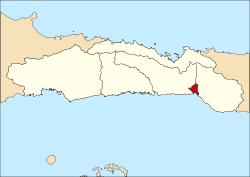
Gorontalo is a city and the capital of the Gorontalo province, Indonesia. It has an area of 79.59 km² and population of about 153,036.[1]
Geography
Gorontalo shares its borders with Bone Bolango Regency (North and East), Tomini Gulf (South), and Gorontalo Regency (West). Its elevation does not rise 500 metres above mean sea level[citation needed] and the average temperature is 26,5 °C[citation needed]
Infrastructure
The largest hospital on Gorontalo is the Aloei Saboe Hospital.[citation needed]
Subdistricts
The city is divided into 6 subdistricts (kecamatan):[2]
- Kota Selatan Subdistrict
- Kota Utara Subdistrict
- Kota Barat Subdistrict
- Kota Timur Subdistrict
- Kota Tengah Subdistrict
- Dungingi Subdistrict
Sister cities
Notes
- ^ http://www.datastatistik-indonesia.com/component/option,com_tabel/task,/Itemid,165/
- ^ "Pemerintah Kota Gorontalo". 2009. Retrieved 2 March 2011.
External links
0°32′N 123°04′E / 0.533°N 123.067°E
