
Harpersfield, New York
Harpersfield, New York | |
|---|---|
| Country | United States |
| State | New York |
| County | Delaware |
| Government | |
| • Type | Town Council |
| • Town Supervisor | James E. Eisel (R) |
| • Town Council | Members' List |
| Area | |
| • Total | 42.4 sq mi (109.7 km2) |
| • Land | 42.1 sq mi (109.2 km2) |
| • Water | 0.2 sq mi (0.6 km2) |
| Elevation | 1,824 ft (556 m) |
| Population (2010) | |
| • Total | 1,577 |
| Time zone | UTC-5 (Eastern (EST)) |
| • Summer (DST) | UTC-4 (EDT) |
| ZIP code | 13786 |
| Area code | 607 |
| FIPS code | 36-32281 |
| GNIS feature ID | 0979049 |
Harpersfield is a town in Delaware County, New York, United States. The population was 1,577 at the 2010 census.
The Town of Harpersfield is on the northern border of the county.
History
The town was formed in 1788 by Colonel John Harper, who fought for the state of New York during the American Revolutionary War.
Geography
The north town line is the border of Schoharie County, New York.
According to the United States Census Bureau, the town has a total area of 42.4 square miles (110 km2), of which, 42.1 square miles (109 km2) of it is land and 0.2 square miles (0.52 km2) of it (0.50%) is water.
Demographics
| Census | Pop. | Note | %± |
|---|---|---|---|
| 1820 | 1,884 | — | |
| 1830 | 1,936 | 2.8% | |
| 1840 | 1,708 | −11.8% | |
| 1850 | 1,613 | −5.6% | |
| 1860 | 1,468 | −9.0% | |
| 1870 | 1,485 | 1.2% | |
| 1880 | 1,420 | −4.4% | |
| 1890 | 1,386 | −2.4% | |
| 1900 | 1,221 | −11.9% | |
| 1910 | 1,244 | 1.9% | |
| 1920 | 1,184 | −4.8% | |
| 1930 | 1,265 | 6.8% | |
| 1940 | 1,200 | −5.1% | |
| 1950 | 1,263 | 5.3% | |
| 1960 | 1,193 | −5.5% | |
| 1970 | 1,423 | 19.3% | |
| 1980 | 1,495 | 5.1% | |
| 1990 | 1,450 | −3.0% | |
| 2000 | 1,603 | 10.6% | |
| 2010 | 1,577 | −1.6% | |
| 2014 (est.) | 1,532 | [1] | −2.9% |
As of the census[3] of 2000, there were 1,603 people, 591 households, and 416 families residing in the town. The population density was 38.0 people per square mile (14.7/km²). There were 913 housing units at an average density of 21.7 per square mile (8.4/km²). The racial makeup of the town was 97.82% White, 0.56% African American, 0.31% Native American, 0.31% Asian, 0.25% from other races, and 0.75% from two or more races. Hispanic or Latino of any race were 2.99% of the population.
There were 591 households out of which 26.6% had children under the age of 18 living with them, 58.0% were married couples living together, 8.3% had a female householder with no husband present, and 29.6% were non-families. 23.9% of all households were made up of individuals and 11.3% had someone living alone who was 65 years of age or older. The average household size was 2.48 and the average family size was 2.92.
In the town the population was spread out with 21.5% under the age of 18, 6.6% from 18 to 24, 20.4% from 25 to 44, 26.6% from 45 to 64, and 25.0% who were 65 years of age or older. The median age was 46 years. For every 100 females there were 90.6 males. For every 100 females age 18 and over, there were 89.0 males.
The median income for a household in the town was $33,333, and the median income for a family was $37,446. Males had a median income of $27,237 versus $21,500 for females. The per capita income for the town was $18,863. About 12.5% of families and 18.3% of the population were below the poverty line, including 38.0% of those under age 18 and 7.4% of those age 65 or over.
Communities and locations in Harpersfield
- Harpersfield – The hamlet of Harpersfield.
- North Harpersfield –
- Stamford – Part of the Village of Stamford is in the northeast corner of the town.
- Sturgis Corner --
42°26′18″N 74°41′15″W / 42.43833°N 74.68750°W
References
- ^ "Annual Estimates of the Resident Population for Incorporated Places: April 1, 2010 to July 1, 2014". Retrieved June 4, 2015.
- ^ "Census of Population and Housing". Census.gov. Retrieved June 4, 2015.
- ^ "American FactFinder". United States Census Bureau. Retrieved 2008-01-31.
Municipalities and communities of Delaware County, New York, United States | ||
|---|---|---|
| Towns | 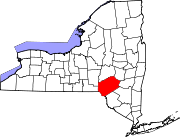 | |
| Villages | ||
| CDPs | ||
| Hamlets |
| |
| Footnotes | ‡This populated place also has portions in an adjacent county or counties | |