Hawalli Governorate
Hawalli Governorate
محافظة حولي | |
|---|---|
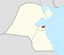
 Map of Kuwait with Hawalli highlighted | |
| Coordinates (Hawalli District): 29°18′20″N 48°01′51″E / 29.30556°N 48.03083°E | |
| Country | |
| Districts | 16 |
| Area | |
| • Total | 82 km2 (32 sq mi) |
| Population (June 2014)[1] | |
| • Total | 890,533 |
| • Density | 11,000/km2 (28,000/sq mi) |
| Time zone | UTC+03 (EAT) |
| ISO 3166 code | KW-HW |
Hawalli Governorate (Arabic: محافظة حولي Muḥāfaẓat Ḥawalli), is one of the six governorates of Kuwait, consisting of the following areas:[2]
- Hawalli
- Bayan
- Mishref
- Maidan Hawalli
- Jabriya
- Rumaithiya
- Salmiya
- Salwa
- Shaab
- Al-salam
- Hattin
- Al-Zahra
- Mubarak Al-Abdullah Al Jaber (West Mishref)
- Al-shuhada
- Al-badae
- Al-Siddiq
Nawaf Al-Ahmad Al-Jaber Al-Sabah become governor in 1962.[3] A more recent governor of the Hawalli governorate is Ahmad Nawaf Al-Ahmad Al-Sabah, now prime minister.
A 2005 estimate reported the population of Hawalli to be 393,861.[4]
A 31 December 2007 estimate reported Hawalli's population to be 714,876.[5]
As of June 2014, the population of Hawalli is estimated to be 890,533.[1]
Sports
Qadsia SC and Al-Salmiya SC are situated in Hawalli governorate
Notable people
- Abdallah Abdalrahman Alruwaished
- Kazem Abal
- Ibrahim Khraibut
- Abdulrasool Abdulreda Behbehani, former President of State Department for Legal Advice and Legislation
References
- ^ a b "Statistical Reports". stat.paci.gov.kw. Archived from the original on 13 March 2014. Retrieved 31 August 2014.
- ^ "Kuwait Info - Information About Kuwait Tourism and Organizations". kuwait-info.com.
- ^ Alan Rush (1987). Al-Sabah: History & Genealogy of Kuwait's Ruling Family, 1752-1987. London: Ithaca Press. ISBN 978-0-86372-081-9.
- ^ "GeoHive : Kuwait". Archived from the original on 23 August 2005. Retrieved 9 August 2005.
- ^ "الهيئة العامة للمعلومات المدنية". paci.hov.kw. Archived from the original on 5 May 2008.


