
Hurricane Dora (1999)
| Category 4 major hurricane (SSHWS/NWS) | |
 Hurricane Dora at peak intensity | |
| Formed | August 6, 1999 |
|---|---|
| Dissipated | August 23, 1999 |
| Highest winds | 1-minute sustained: 140 mph (220 km/h) |
| Lowest pressure | 943 mbar (hPa); 27.85 inHg |
| Fatalities | None reported |
| Damage | Minimal |
| Areas affected | Hawaii, Johnston Atoll |
| Part of the 1999 Pacific hurricane season and the 1999 Pacific typhoon season | |
Hurricane Dora was one of few tropical cyclones to track across all three north Pacific basins. The fourth named storm, third hurricane, and second major hurricane of the 1999 Pacific hurricane season, Dora developed on August 6 from a tropical wave to the south of Mexico. Forming as a tropical depression, it gradually strengthened and was upgraded to Tropical Storm Dora later that day. Thereafter, Dora began heading in a steadily westward, before becoming a hurricane on August 8. Under warm sea surface temperatures (SST's) and low wind shear, the storm continued to intensify, eventually peaking as a 140 mph (220 km/h) Category 4 hurricane on August 12. While passing south of Hawaii, Dora significantly fluctuated in intensity, ranging from winds of 140 mph (220 km/h) to a low-end Category 1 hurricane. While crossing the International Dateline on August 20, Dora weakened to a tropical storm. After weakening to a tropical depression on August 22, the storm dissipated on August 23 while centered several hundred miles north of Wake Island.
Although it never made landfall, Dora produced high surf, gale force winds and light rain across southeastern Hawaii and Johnston Island. There were no reported deaths or injuries from the hurricane.
Meteorological history

Tropical storm (39–73 mph, 63–118 km/h)
Category 1 (74–95 mph, 119–153 km/h)
Category 2 (96–110 mph, 154–177 km/h)
Category 3 (111–129 mph, 178–208 km/h)
Category 4 (130–156 mph, 209–251 km/h)
Category 5 (≥157 mph, ≥252 km/h)
Unknown
A tropical wave emerged into the Atlantic Ocean from the west coast of Africa on July 23. It tracked through the Atlantic and Caribbean Sea for several days with minimal development. By August 4, the system entered the Pacific Ocean, accompanied by disorganized convection. During the next 24 hours, satellite imagery noted evidence of a low-level circulation, as well as the formation of curved convective banding. As a result, it is estimated that Tropical Depression Seven-E developed at 0000 UTC on August 6, while located about 335 miles (540 km) south of Acapulco.[1] Three hours later, the National Hurricane Center began issuing advisories on the depression and forecasted significant intensification.[2] Despite initial vertical wind shear, the depression steadily intensified and was upgraded to Tropical Storm Dora later that day.[1] Upon becoming a tropical storm, the National Hurricane Center noted "there would seem to be no reason why Dora should not strengthen", citing decent outflow on the western side of the storm and SST's of nearly 84 °F (29 °C).[3] Tracking west-northwestward and then westward, Dora continued to strengthen and was upgraded to a hurricane on August 8.
Moving westward along a decaying subtropical ridge, Dora steadily increased to hurricane status on August 8, based on estimates through the Dvorak technique. Weak wind shear ahead of the storm and warm waters allowed continued strengthening as a small, well-defined eye formed. On August 12, Dora reached its peak intensity of 140 mph (220 km/h) as the barometric pressure dropped to a minimum of 943 mbar. Shortly after its peak intensity, Dora underwent an eyewall replacement cycle, resulting in a brief weakening before again restrengthening to winds of 140 mph (220 km/h) late on August 13. Dora never strengthened any further as the storm encountered cooler waters and light wind shear.[1][4][5]
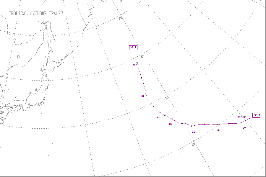
Subsequent to peaking in intensity, Dora encountered cooler waters and increased wind shear.[1][4][5] On August 14 it crossed into the central Pacific Ocean as a Category 2 hurricane on the Saffir-Simpson Hurricane Scale; the duty of hurricane warnings were transferred from the National Hurricane Center to the Central Pacific Hurricane Center. Dora again encountered favorable conditions, and on August 15 re-intensified to major hurricane status as it passed 200 miles (320 km) south of Big Island, Hawaii. The secondary peak intensity was brief, as weakening occurred after the forward speed increased. Dora passed 65 miles (105 km) south of Johnston Island on August 18 before turning west-northwest, and on August 19 it crossed the International Date Line as a 70 mph (115 km/h) tropical storm; the Joint Typhoon Warning Center tracked the remainder of the duration of Dora. The storm encountered stronger wind shear, and by August 21 winds decreased to below tropical storm force. On August 23, the circulation became exposed from the main convection, and at 1800 UTC Tropical Depression Dora dissipated about 450 miles (725 km) northeast of Wake Island.[1][4][6]
Impact and records

On August 16, forecast models predicted Dora would bypass Johnston Island a short distance to the south, with some concerns of a direct hit on the island.[1][7][8][9][10] As a result of the threat, about 1,200 workers and residents evacuated Johnston Atoll to Hawaii. Prior to leaving, workers secured construction equipment and other loose items. Some biologists on Johnston Atoll were concerned that the hurricane would severely impact the reproductive cycle of over 150,000 birds in the Johnston Atoll Wildlife Refuge, a concern expressed after Hurricane John in 1994 killed 80% of the bird population during its impact on Johnston Atoll.[11] Additionally, the Central Pacific Hurricane Center predicted Dora would strike Wake Island as a minimal typhoon, though it did not occur.[1][7][8][9][10]
An ocean swell from Dora produced 8 – 20 foot (2 – 6 m) waves along the east and southern shores of the island of Hawaii. This prompted local officials to close all beaches, campsites and nature trails in the Puna and Kau districts due to the deteriorating conditions.[12] The outer rainbands produced winds of up to 60 mph (95 km/h) at some high elevations, and also resulted in some light rainfall.[13] Hurricane Dora also produced rough surf on Johnston Island, with one forecaster remarking the surf was the most severe aspect of the storm.[14] The automatic station at Johnston Atoll reported wind gusts between 40 — 45 mph (75 – 85 km/h) for two hours. Overall effects were minimal, and there were no reports of damage or injuries.[13]
With a total track of 6,500 miles (10,500 km), Hurricane Dora had the second longest track of a Pacific hurricane, behind only Hurricane John of 1994; the length of the track of Dora was more than four times the basin average.[15] Dora was also the first Pacific hurricane to come close enough to be detected by radar.[16] In addition, the hurricane was the first tropical cyclone to move across all three Pacific basins since John in 1994.[1]
See also
- Hurricane Tina (1992)
- Hurricane John (1994)
- Hurricane Genevieve (2014)
- List of Category 4 Pacific hurricanes
References
- ^ a b c d e f g h Miles B. Lawrence (November 23, 1999). "Hurricane Dora Preliminary Report". National Hurricane Center. Retrieved 2012-03-09.
- ^ Lixion A. Avila (August 5, 1999). "Tropical Depression Seven-E Discussion Number 1". National Hurricane Center. Retrieved 2012-03-09.
- ^ James B. Franklin (August 6, 1999). "Tropical Storm Dora Discussion Number 4". National Hurricane Center. Retrieved 2012-03-09.
- ^ a b c Gary Padgett. "Gary Padgett's report on Hurricane Dora". Archived from the original on 2006-06-29. Retrieved 2006-11-28.
- ^ a b Beven. "Hurricane Dora Tropical Discussion Archive #29". National Hurricane Center. Retrieved 2006-11-28.
- ^ Beven. "Hurricane Dora Tropical Discussion Archive #33". National Hurricane Center. Retrieved 2006-11-28.
- ^ a b Habuzel. "Hurricane Dora Tropical Discussion Archive #44". Central Pacific Hurricane Center. Retrieved 2006-11-29.
- ^ a b Habuzel. "Hurricane Dora Tropical Discussion Archive #45". Central Pacific Hurricane Center. Retrieved 2006-11-29.
- ^ a b Habuzel. "Hurricane Dora Tropical Discussion Archive #46". Central Pacific Hurricane Center. Retrieved 2006-11-29.
- ^ a b Habuzel. "Hurricane Dora Tropical Discussion Archive #48". Central Pacific Hurricane Center. Retrieved 2006-11-29.
- ^ Mary Adamski (1999). "Hurricane evacuees start arriving in Hawaii". Star-Bulletin. Retrieved 2007-04-20.
- ^ National Climatic Data Center (1999). "Event Report for Hawaii". Retrieved 2007-07-17.
- ^ a b Central Pacific Hurricane Center (1999). "The 1999 Central Pacific Hurricane Season". Retrieved 2007-07-17.
- ^ Rosendal. "Hurricane Dora Tropical Discussion Archive #50". Central Pacific Hurricane Center. Retrieved 2006-11-30.
- ^ Neal Dorst (2004). "FAQ: What is the farthest a tropical cyclone has traveled". NOAA. Retrieved 2007-04-23.
- ^ Andy Nash (2003). "Hurricane Jimema report". NOAA. Retrieved 2007-04-23.
External links
- Hurricane Dora Tropical Cyclone Report
- JMA General Information of Severe Tropical Storm Dora (9911) from Digital Typhoon
- JMA Best Track Data (Graphics) of Severe Tropical Storm Dora (9911)
- JMA Best Track Data (Text)
Tropical cyclones of the 1999 Pacific hurricane season | ||
|---|---|---|
 | ||
Tropical cyclones of the 1999 Pacific typhoon season | ||
|---|---|---|
 | ||