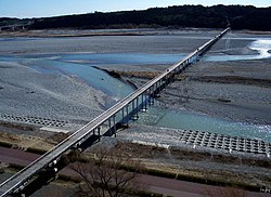
Hōrai Bridge
Hōrai Bridge 蓬莱橋 | |
|---|---|
 Hōrai Bridge | |
| Coordinates | 34°49′17″N 138°11′10″E / 34.821390°N 138.186213°E |
| Crosses | Ōi River |
| Locale | Shimada, Shizuoka, Japan |
| Characteristics | |
| Total length | 897.422 metres (2,944 ft) |
| Width | 2.7 metres (9 ft) |
| History | |
| Construction end | 1879 |
| Statistics | |
| Toll | yes |
| Location | |
 | |
The Hōrai Bridge (蓬莱橋, Hōrai-bashi) is a wooden pedestrian bridge over the Ōi River located in the city of Shimada, Shizuoka Prefecture, Japan. It was constructed in 1879 With a length of 897.422 metres (2,944.30 ft), the bridge was registered in The Guinness Book of Records as the longest wooden walking bridge in the world in 1997.
History
The Hōrai Bridge is on the Edo period route of the Tōkaidō, connecting Edo with Kyoto. The Tokugawa shogunate expressly forbid the construction of any bridge or ferry service over the Ōi River for defensive purposes, forcing travelers to wade across its shallows. However, whenever the river flooded due to strong or long rains, crossing the river was impossible. During period of long rains, visitors were sometimes forced to stay at Shimada-juku or Kanaya-juku, sometimes for several days. Following the Meiji restoration, former samurai loyal to the Tokugawa clan settled in the Makinohara area and began to develop tea plantations. To facilitate crossing the river, this bridge was built in 1879. In 1965 its wooden pilings were replaced by concrete, but its wooden top was retained.
External links
 Media related to Horai Bridge (Shimada) at Wikimedia Commons
- The Hourai Bridge
- Shimada City home page
- Shizuoka Prefecture home page
