Kadugli Airport
Appearance
Kadugli Airport | |||||||||||
|---|---|---|---|---|---|---|---|---|---|---|---|
| Summary | |||||||||||
| Airport type | Public / Military | ||||||||||
| Operator | Government | ||||||||||
| Location | Kadugli, Sudan | ||||||||||
| Elevation AMSL | 1,848 ft / 563 m | ||||||||||
| Coordinates | 11°08′16″N 029°42′04″E / 11.13778°N 29.70111°E | ||||||||||
| Map | |||||||||||
 | |||||||||||
| Runways | |||||||||||
| |||||||||||
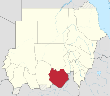
Kadugli Airport (IATA: KDX, ICAO: HSLI) is an airport serving Kadugli[1] (also spelled Kaduqli), the capital city of the state of South Kurdufan (or South Kordofan) in Sudan.
Facilities
The airport resides at an elevation of 1,848 feet (563 m) above mean sea level. It has one runway designated 06/24 with an asphalt surface measuring 2,553 by 53 metres (8,376 ft × 174 ft).[1]
Airlines and destinations
| Airlines | Destinations |
|---|---|
| Tarco Airlines | Khartoum[3] |
Kadugli Air Base
The airport hosts Sudanese Air Force Helicopter Squadron (Mil Mi-8, Mil Mi-24, Mil Mi-35).[4]
Incidents
- On 10 November 1979, Douglas C-47B ST-AHH of the National Agriculture Organisation crashed at Kadugli Airport and was destroyed by the subsequent fire.[5]
References
- ^ a b c Airport information for HSLI from DAFIF (effective October 2006)
- ^ Airport information for HSLI at Great Circle Mapper. Source: DAFIF (effective October 2006).
- ^ "Tarco Air - Flight timetable". Archived from the original on 2015-07-06. Retrieved 2015-08-14.
- ^ "Orbats".
- ^ "ST-AHH Accident description". Aviation Safety Network. Retrieved 29 July 2010.
External links

