Kalinga Park
| Kalinga Park | |
|---|---|
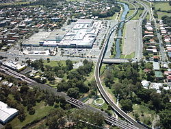
 Parts of Kalinga Park (foreground), Shaw Park and Mercer Park (background) looking west from Clayfield | |
 | |
| Type | Public park |
| Location | Clayfield, Queensland |
| Coordinates | 27°24′24″S 153°03′07″E / 27.40675°S 153.05182°E |
| Created | 1910 |
| Operated by | Brisbane City Council |
| Status | Open |
| Website | http://www.brisbane.qld.gov.au/facilities-recreation/parks-gardens/parks-by-suburb/clayfield-parks/index.htm |
Kalinga Park is a park located on northside of Brisbane, Australia. It is community park land associated with the locality of Kalinga, in the suburbs of Clayfield and Wooloowin.[1]
History
Previously known as Anzac Memorial Park, Kalinga Park was officially opened in 1910.
In 1920, Soldiers Honour Gates were opened as remembrance of the patriotic services and sacrifices of the men who enlisted from the Kalinga district and fought for their country in the Great War. A roadway through the park was built in 1924 and is still informally known as Diggers Drive.[2]
A large army staging camp was located at the site during World War II.[3]
In 2002, the Brisbane City Council declared that the Kalinga Park "should continue as a park that serves the District and caters for informal recreation and formal sports".[4]
Kalinga Park has undergone development with the introduction of the Airport Link.

Facilities and attractions
The park contains several club facilities including a petanque playing area, a tennis court, ovals and open fields. A natural watercourse, Kedron Brook[5] runs across its northern extent. Bicycle and walking tracks traverse the park. The park also includes electric barbecue areas, children's playgrounds, kid-size bike roadway and dog off-leash areas. Although suburban, the park is home to a wide variety of wildlife, including ducks, cockatoos, rainbow lorikeets, possums, Eastern water dragons, and the occasional koala.
