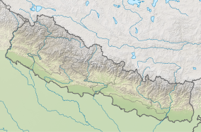
Kanchenjunga Conservation Area
| Kanchenjunga Conservation Area | |
|---|---|
| Nepali: कञ्चनजङ्घा संरक्षण क्षेत्र | |
IUCN category VI (protected area with sustainable use of natural resources) | |
 On route to the Pathibhara Devi Temple | |
| Location | Nepal |
| Coordinates | 27°42′56″N 87°55′42″E / 27.7155°N 87.9282°E |
| Area | 2,035 km2 (786 sq mi) |
| Established | 1997 |
| Governing body | Department of National Parks and Wildlife Conservation |
Kanchenjunga Conservation Area is a protected area in the Himalayas of eastern Nepal that was established in 1997. It covers 2,035 km2 (786 sq mi) in the Taplejung District and comprises two peaks of Kanchenjunga. In the north it adjoins the Qomolangma National Nature Preserve in Tibet, and in the east the Khangchendzonga National Park in Sikkim.[1] To the west it borders the Sankhuwasabha District. It ranges in elevation from 1,200 to 8,586 m (3,937 to 28,169 ft). It is part of the Sacred Himalayan Landscape, which is being developed by WWF Nepal in partnership with the International Centre for Integrated Mountain Development.[2]
History
When the Kanchenjunga Conservation Area was designated in March 1997, it was Nepal's third Conservation Area. In April 2003, a Kanchenjunga Conservation Area Management Council was formed with the support of WWF Nepal, comprising seven Conservation Area User Committees, 44 User Groups, and 32 Mother Groups. These community based institutions support effective implementation of all planned activities. In August 2006, the Government of Nepal handed over the management of the Kanchenjunga Conservation Area to the Management Council.[2]
Vegetation
The landscape of the Kanchenjunga Conservation Area comprises cultivated lands, forests, pastures, rivers, high elevation lakes and glaciers.[1]
Fauna
Mammal species include the snow leopard, Asian black bear, and red panda. Bird species symbolic of the area include the golden-breasted fulvetta, snow cock, blood pheasant, and red-billed chough.[1]
In April 2012, a leopard cat was recorded by a camera trap at an elevation of 4,474 m (14,678 ft). This record constitutes the highest known record to date. A melanistic leopard was photographed at an elevation of 4,300 m (14,100 ft) in May 2012.[3] Yellow-throated marten has been recorded up to 4,510 m (14,800 ft) elevation in alpine meadow.[4]
References
- ^ a b c Bhuju, U. R.; Shakya, P. R.; Basnet, T. B. & Shrestha, S. (2007). Nepal Biodiversity Resource Book. Protected Areas, Ramsar Sites, and World Heritage Sites. Kathmandu: International Centre for Integrated Mountain Development, Ministry of Environment, Science and Technology, in cooperation with United Nations Environment Programme, Regional Office for Asia and the Pacific. ISBN 978-92-9115-033-5.
- ^ a b Aryal, K. P.; Kerkhoff, E. E.; Maskey, N.; Sherchan, R. (2010). Shifting Cultivation in the Sacred Himalayan Landscape. A Case Study in the Kangchenjunga Conservation Area (PDF). Kathmandu: WWF Nepal.
- ^ Thapa, K.; Pradhan, N. M. B.; Berker, J.; Dhakal, M.; Bhandari, A. R.; Gurung, G. S.; Rai, D. P.; Thapa, G. J.; Shrestha, S.; Singh, G. R. (2013). "High elevation record of a leopard cat in the Kangchenjunga Conservation Area, Nepal". Cat News (58): 26–27.
- ^ Appel, A.; Khatiwada, A. P. (2014). "Yellow-throated Martens Martes flavigula in the Kanchenjunga Conservation Area, Nepal". Small Carnivore Conservation 50: 14–19.
External links
- BirdLife International. "Important Bird Areas factsheet: Kanchenjungha Conservation Area".
- Department of National Parks and Wildlife Conservation, Nepal: Kanchenjunga Conservation Area


