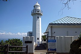
Kannonzaki Park
Appearance

Kannonzaki Park (Template:Lang-ja) is a prefectural-level combined scenic-city park, located at Cape Kannon (Kannonzaki), the northeastern tip of the Miura Peninsula, Yokosuka City, Kanagawa, Japan. It is a park that makes the most of the rich nature, such as the laurel forest and the coastal rocky shore of the area.
In its 70.2-hectare area are found: the park management center, the Kannonzaki Lighthouse, the Yokosuka Museum of Art, the Kannonzaki Nature Museum (Template:Lang-ja),[1] a day camp site, the coastal and hill trails, etc.[2]
The visitors to this park can enjoy "Ship watching",[3] as it is located on the Uraga Channel, Japan's busiest sea lane.
-
The Kannonzaki Museum of Natural History (right) and its restaurant (left)
-
The Flower Plaza
-
The View Garden for Ship watching
-
Tokyo Bay Maritime Traffic Information Service Radar (2016)
-
The Yokosuka Museum of Art and its restaurant
See also
References
- ^ Kannonzaki Nature Museum (in Japanese).
- ^ Kannonzaki Park. JapanReference.
- ^ Yokosuka Eco-tour "Ship Watching over the Uraga Channel (Yokosuka City) (in Japanese).
External links
35°15′22.8″N 139°44′27″E / 35.256333°N 139.74083°E
Wikimedia Commons has media related to Cape Kannon, Yokosuka, Japan.
- Prefectural Kannonzaki Park (Kanagawa Prefecture) (in Japanese)


