
Kavečany
Kavečany | |
|---|---|
Borough | |
 General view of houses in Kavečany (July 2007) | |
 Flag  Coat of arms | |
 Location within Košice | |
| Country | Slovakia |
| Region | Košice |
| District | Košice I |
| Village | 1347 (first known record) |
| Borough | 1976 |
| Government | |
| • Mayor | Martin Balčík (Independent) |
| Area | |
• Total | 10.05 km2 (3.88 sq mi) |
| Elevation | 453 m (1,486 ft) |
| Population (31 December 2017) | |
• Total | 1,310 |
| • Density | 130/km2 (340/sq mi) |
| Population by ethnicity (2011) | |
| • Slovak | 95.2% |
| • Hungarian | 0.2% |
| • Rusyn | 0.2% |
| • Other | 0.5% |
| • Unreported | 3.9% |
| Population by religion (2011) | |
| • Roman Catholic | 82.5% |
| • Calvinist | 1.3% |
| • Greek Catholic | 0.9% |
| • Lutheran | 0.8% |
| • Other | 1.8% |
| • Non-religious | 7.3% |
| • Unreported | 5.4% |
| Postal code | 040 01 |
| Area code | +421-55 |
| Car plate | KE |
| Website | www.kosicekavecany.sk |
| Source [3] | |
Kavečany (Hungarian: Kavocsán) is a borough (city ward) of Košice, Slovakia. The borough is situated 6 km northwest of Košice, at an altitude of roughly 453 metres (1,486 ft) above sea level, in the Košice I district. Kavečany retains a rural character, with a population of more than 1150 inhabitants. It's known mostly as a place for recreation and relaxation. Kavečany is famous for its ski center, summer toboggan track, and the Košice Zoo.
History
[edit]Until 1976, Kavečany was a separate municipality, classified as a village. In 1976, it was merged with the city of Košice and became one of its outer boroughs, as part of the urban Košice I district.
The village of Kavečany first appeared in written records in 1347.
Tourism
[edit]Kavečany is a popular place mostly for recreational activities. The ski resort offers a variety of services including snowmaking. There are excellent conditions for both cross-country and downhill skiing here. Other local attractions include the summer toboggan track and the third-largest zoological garden in Europe. The surrounding countryside offers many hiking and biking trails which extend to the great and attractive area of Čierna Hora.
Cultural festivals
[edit]The most interesting cultural and social events during the year are associated with the local folklore ensemble "Kavečianka", who preserves the traditions of their ancestors through songs and dance routines.
Sports events
[edit]The annual half marathon run and the new motocross race are the most significant sports events in the village.
Basic data
[edit]- Latitude: 48.7833, Longitude: 21.2167
- Latitude (DMS): 48° 46' 60N, Longitude (DMS): 21° 13' 0E
- Altitude: 1,217 feet (350 m)
Gallery
[edit]-
 Panorama of Kavečany among Košice's northern hills
 -
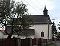 Church of St Peter and St Paul
 -
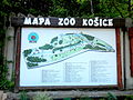 Map of Košice zoo in Kavečany
 -
 Seals at the Košice zoo in Kavečany
 -
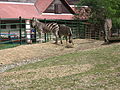 Zebras at the Košice zoo in Kavečany
 -
 Summer toboggan track near Kavečany
 -
 Hrešná skiing slope, local ski centre
 -
 Chalet at Hrešná
 -
 A view of the Slanské Hills range from Kavečany
 -
 A view of the Slanské Hills range from Kavečany


References
[edit]- ^ SODB - Košice - Kavečany, 2011
- ^ SODB - Košice - Kavečany, 2011
- ^ Mestská a obecná štatistika SR (urgently needs an updated statistics link for 2018) Archived 2007-04-27 at the Wayback Machine
External links
[edit]- Official website of the Kavečany borough
- Article on the Kavečany borough at Cassovia.sk
- Ski center information (in Slovak and Hungarian languages)
- Official website of Košice
48°47′N 21°13′E / 48.783°N 21.217°E
| International | |
|---|---|
| National | |
This Košice Region geography article is a stub. You can help Wikipedia by expanding it. |