
Kim Il Sung Square
Kim Il Sung Square | |
|---|---|
| Public square | |
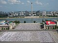
.jpg) The square in 2014 | |
| Opening date | August 1954 |
| Area | 75,000 square meters (810,000 sq ft) |
| Surface | concrete |
| Dedicated to | Kim Il Sung |
| Owner | City of Pyongyang |
| Location | Taedongmun-dong, Chung-guyok, Pyongyang |

| |
| Korean name | |
| Chosŏn'gŭl | 김일성광장 |
| Hancha | |
| Revised Romanization | Gim Il-seong Gwangjang |
| McCune–Reischauer | Kim Il-sŏng Kwangjang |
| Coordinates: 39°01′10″N 125°45′09″E / 39.01953°N 125.75247°E | |
Kim Il Sung Square is a large city square in the Central District of Pyongyang, North Korea,[1] and is named after the country's founding leader, Kim Il Sung. The square was constructed in 1954 according to a master plan for reconstructing the capital after the destruction of the Korean War.[1] It was opened in August 1954.[2] The square is located on the foot of the Namsan Hill,[1] west bank of the Taedong River, directly opposite the Juche Tower on the other side of the river. It is the 37th largest square in the world, having an area of about 75,000 square metres (807,293 square feet) which can accommodate a rally of more than 100,000 people.[3][4] The square has a great cultural significance, as it is a common gathering place for concerts, rallies, dances and military parades and is often featured in media concerning North Korea.
Overview[edit]
The Kim Il Sung Square is at the center of Pyongyang on the west bank of the Taedong River. It is similar in form and design to the Tiananmen Square in Beijing and is used for the same purposes. Since the completion of the square, multiple parades have been held to commemorate many different events and also to show the world the military capabilities of North Korea. The Kim Il Sung Square is architecturally more refined with its dramatic riverside setting. If an observer stands in the square, the Tower of the Juche Idea on the opposite bank appears to be located directly towards the west end of the square, although it is actually across the Taedong River, as with the Workers' Party Monument and the Mansudae Grand Monument. This optical effect is created because the square is a few meters lower in the center when compared to the side near the Taedong River.[5] Surrounding the square are a number of government buildings, with the Great People's Study House located at the east end of the square. At the south end are two flag poles which were installed in 2013 for use in national events.
Under the square, there is a department store selling products such as toys.[6]
Kim Il Sung Square is the "kilometre zero" of North Korea from where all national road distances are measured.[7]
History[edit]
Portraits of Karl Marx and Vladimir Lenin once hung on one of the buildings surrounding the square, but were taken down sometime in 2012.[8] During Kim Jong Il's rule, only Kim Il Sung hung on these buildings, although his portrait on the building below the flag of the DPRK was removed.[8] When Kim Jong-il died, his portrait was added to the buildings in commemoration.
After the Singapore Trump-Kim summit in 2018, North Korea removed the anti-American imperialism propaganda in Kim Il Sung Square. Also, North Korea cancelled the annual ‘anti-US’ rally event in 2018. In 2017, the protests that were held in Kim Il Sung Square were supposedly attended by 100,000 people. Furthermore, North Korea issued special anti-US postage stamps in 2017.[9][10]
The old ceremonial grandstand on the square's south side was renovated in 2020.
Gallery[edit]
-
 Pyongyang as seen from the Juche Tower, facing west across the Taedong River. The large square in the center is Kim Il Sung Square; the large building behind it is the Grand People's Study House.
 -
 The Kim Il Sung square, with the Grand People's Study House, also known as the National Library of North Korea.
 -
 The Kim Il Sung Square and the Tower of Juche Idea seen from the Grand People's Study House.
 -
 The Kim Il Sung square, as viewed from the Study Hall to the Juche Tower
 -
 New Year fireworks at Kim Il Sung Square, January 2017.
 -
North Korean female soldiers goose-stepping through Kim Il Sung Square while rehearsing for the Day of the Foundation of the Republic parade in 2011.
-
 Parade in honor of the 70th anniversary of the end of the Korean War, held in 27 July 2023.


.jpg)

References[edit]
- ^ a b c "Kim Il Sung Square". Naenara. Retrieved 2015-12-05.
- ^ Martin, Bradley K. (2006) Under the Loving Care of the Fatherly Leader: North Korea And the Kim Dynasty. St Martins Press. ISBN 978-0-312-32322-6. p. 774
- ^ Pyongyang Images Archived 2019-03-21 at the Wayback Machine, New Korea Tours
- ^ Kwan, Lee Kyo. Mammoth Underground Square and Road in Pyongyang Archived 2005-02-07 at the Wayback Machine. Digital Chosunilbo. July 22, 2001
- ^ "Kim Il Sung Square". Archived from the original on 2009-03-24.
- ^ "A diplomat's life: The pleasures of retail therapy in the North Korean capital". NK News. 2021-09-27. Retrieved 2021-09-28.
- ^ Talmadge, Eric (20 November 2017). "Lonely highways: On the road in Kim Jong Un's North Korea". AP News. Retrieved 5 December 2021.
- ^ a b "Kim Il-sung Square gets a [relatively] new look". North Korean Economy Watch. Retrieved 2021-09-28.
- ^ "North Korea cancels annual 'anti-US' rally as relations improve". The Independent. 2018-06-25. Retrieved 2021-06-24.
- ^ Smith, Josh (2018-06-24). "North Korea appears to be getting rid of its anti-American propaganda after the Trump-Kim summit". Business Insider. Archived from the original on 2020-11-29. Retrieved 2021-06-24.
Further reading[edit]
- Corfield, Justin (2014). "Kim Il Sung Square". Historical Dictionary of Pyongyang. London: Anthem Press. ISBN 978-1-78308-341-1.
External links[edit]
- 360° Interactive panorama of Kim Il-sung Square at night images
- Asian Historical Architecture: Kim Il-sung Square
- Traveller's blog with pictures from North Korea ; Several photos of Kim Il Sung Square
- Kim Il-sung Square, Pyongyang, North Korea (video) — practising for the Mass games