
Klatovy
Klatovy | |
|---|---|
 Black Tower and Jesuit Church | |
 Flag  Coat of arms | |
 Klatovy Location in the Czech Republic | |
| Coordinates: 49°23′43″N 13°17′42″E / 49.39528°N 13.29500°E | |
| Country | |
| Region | Plzeň |
| District | Klatovy |
| First mentioned | 1253 |
| Government | |
| • Mayor | Rudolf Salvetr (ODS) |
| Area | |
| • Total | 80.85 km2 (31.22 sq mi) |
| Elevation | 405 m (1,329 ft) |
| Population (2022-01-01)[1] | |
| • Total | 21,587 |
| • Density | 270/km2 (690/sq mi) |
| Time zone | UTC+1 (CET) |
| • Summer (DST) | UTC+2 (CEST) |
| Postal code | 339 01 |
| Website | www |
Klatovy (Czech pronunciation: [ˈklatovɪ]; German: Klattau) is a town in the Plzeň Region of the Czech Republic. It has about 22,000 inhabitants. The town centre is well preserved and is protected by law as an urban monument zone.
Administrative parts
Klatovy is made up of 30 administrative parts (5 town parts and 25 villages):
- Klatovy I
- Klatovy II
- Klatovy III
- Klatovy IV
- Klatovy V
- Beňovy
- Chaloupky
- Čínov
- Dehtín
- Dobrá Voda
- Drslavice
- Habartice
- Kal
- Kosmáčov
- Křištín
- Kvaslice
- Kydliny
- Lažánky
- Luby
- Otín
- Pihovice
- Sobětice
- Štěpánovice
- Střeziměř
- Tajanov
- Točník
- Tupadly
- Věckovice
- Vícenice
- Vítkovice
Habartice, Kvaslice and Vítkovice, and Dobrá Voda, Křištín and Střeziměř form two exclaves of the municipal territory.
Etymology
According to one theory, the name Klatovy was derived from the personal name Klát, meaning "Klát's (court)". The name Klát has then its origin in the Old Czech word klát, which meant "stump" or "log". According to the second theory, the name Klatovy was derived directly from klát.[2]
Geography

Klatovy is located about 38 km (24 mi) south of Plzeň. It lies in the Švihov Highlands except for the two exclaves, which lie one in the Blatná Uplands and one in the Bohemian Forest Foothills. The highest point is the hill Boudovka at 729 m (2,392 ft) above sea level, located in the southern (Bohemian Forest Foothills) exclave. A dominant feature of the built-up area is the hill Hůrka (498 m).
The town is situated on the right bank of the Úhlava River. The Drnový Stream, a tributary of the Úhlava, flows through the town.
History
The first written mention of Klatovy is from 1253, when it was a small settlement on a trade route from Bohemia to Bavaria. Between 1260 and 1263, a royal town was made from the settlement by Ottokar II of Bohemia. The town walls were built and between the 13th and 16th centuries were improved. Despite the Hussite Wars and a fire in 1464, which destroyed all the suburbs, the development of the town continued. At the beginning of the 16th century, Klatovy was one of the ten most important towns in Czech lands.[3][4]
In the 16th century, Klatovy continued to flourish and many important buildings were built. But the town was damaged several fires, and the Thirty Years' War caused decline. In the mid-17th century, Jesuits came into the town and started not only building development, but also the development of education. However, in a fire in 1689 started by arsonists, all the Gothic and Renaissance monuments burned down.[3]
In the 18th century, Klatovy became the administrative centre of the region. In the early 19th century, part of the fortifications were demolished and the town changed its architectural face. In the second half of the19th century, Klatovy became the centre of cultural and social life. The development of trade was supported by the construction of new railway and road networks.[3]
During World War II, Klatovy was occupied by Germany. The Germans operated a Gestapo prison in the town.[5] In 1942, Klatovy was the centre of the resistance movement, which was harshly suppressed by the execution of 73 patriots in the Spálený Forest at the time of Reinhard Heydrich.[6] In 1945, some parts of the town were badly damaged by bombing , and the railway station building was completely destroyed.[7] Klatovy was liberated on 5 May 1945 by the US Army. The town's remaining German population was expelled in accordance with the Potsdam Agreement in 1945.
Demographics
|
|
| ||||||||||||||||||||||||||||||||||||||||||||||||||||||
| Source: Censuses[8][9] | ||||||||||||||||||||||||||||||||||||||||||||||||||||||||
Sport
The town's football club SK Klatovy 1898 is one of the oldest football clubs in the country.[10] Nowadays it plays in the fourth tier of the Czech football system.
Sights
.jpg)
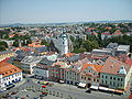
The oldest part of the town surrounded by fragments of town walls is protected as an urban monument zone since 1992. The mains sights are:[3][4]
- Black Tower, built in 1547–1557 as a watchtower, nowadays a lookout tower open to the public;
- Baroque Jesuit Pharmacy with equipment from the 17th century;
- Baroque Jesuit Church of the Immaculate Conception of the Virgin Mary and of Saint Ignatius, built in 1655–1679, with catacombs under the church;
- Baroque Church of Saint Lawrence built in 1694–1709;
- Gothic houses on the Míru Square;
- Town museum in a Art Nouveau building from 1905;
- Roman Catholic Church of the Nativity of Mary from the end of the 13th century.
Notable people
- Bohuslav Balbín (1621–1688), writer, historian, Jesuit
- Václav Matěj Kramerius (1753–1808), publisher, journalist and writer
- Josef Dobrovský (1753–1829), philologist, historian
- Franz Kiwisch von Rotterau (1814–1852), medical professor and gynaecological researcher
- Josef Hlávka (1831–1908), architect
- August Breisky (1832–1889), medical professor and gynaecological researcher
- Johann Brotan (1843–1918), Austrian mechanical engineer
- Karel Klostermann (1848–1923), writer
- Jaroslav Vrchlický (1853–1912), lyrical poet
- Josef Klička (1855–1937), organist, violinist and composer
- Lubor Niederle (1865–1944), founder of Czech archaeology
- Václav Fišer (born 1947), long jumper and triple jumper
- Ivana Sekyrová (born 1971), long-distance runner
- Petr Frydrych (born 1988), javelin thrower
- Tereza Krejčiříková (born 1996), footballer
Twin towns – sister cities
Gallery
-
 Black Tower
 -
 White Tower
 -
 View to the southeast
 -
 Town museum
.jpg)
.jpg)


References
- ^ "Population of Municipalities – 1 January 2022". Czech Statistical Office. 2022-04-29.
- ^ "Etymologický základ názvu města Klatovy". Ptejte se knihovny (in Czech). National Library of the Czech Republic. Retrieved 2022-11-10.
- ^ a b c d "Historie a památky Klatov – stručný přehled" (in Czech). Město Klatovy. Retrieved 2022-11-10.
- ^ a b "Klatovy" (in Czech). Turistika.cz. Retrieved 2021-06-10.
- ^ "Gestapogefängnis Klattau". Bundesarchiv.de (in German). Retrieved 21 August 2022.
- ^ "Klatovy si připomínají 75. výročí atentátu na Heydricha" (in Czech). Czech Radio. 2017-05-09. Retrieved 2022-11-10.
- ^ "Podívejte se: Před 76 lety bylo rozbombardováno klatovské vlakové nádraží" (in Czech). Deník.cz. 2021-04-20. Retrieved 2022-11-10.
- ^ "Historický lexikon obcí České republiky 1869–2011 – Okres Klatovy" (in Czech). Czech Statistical Office. 2015-12-21. pp. 13–14.
- ^ "Population Census 2021: Population by sex". Public Database. Czech Statistical Office. 2021-03-27.
- ^ "10 nejstarších fotbalových klubů v České republice" (in Czech). Město Klatovy. Retrieved 2021-06-10.
- ^ "Partnerská města" (in Czech). Město Klatovy. Retrieved 2022-03-23.
External links
| International | |
|---|---|
| National | |