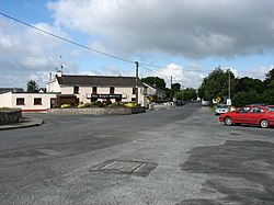
Knockananna
This article includes a list of general references, but it lacks sufficient corresponding inline citations. (October 2021) |
Knockananna
Cnoc an Eanaigh | |
|---|---|
Village | |
 Centre of Knockananna | |
| Coordinates: 52°52′26″N 6°29′35″W / 52.874000°N 6.493000°W | |
| Country | Ireland |
| Province | Leinster |
| County | County Wicklow |
| Elevation | 205 m (673 ft) |
| Population (2016)[1] | 143 |
| Irish Grid Reference | T010814 |
Knockananna (Irish: Cnoc an Eanaigh, meaning 'hill of the marsh')[2] is a village in County Wicklow, Ireland.
Knockananna lies close to the border between County Wicklow and County Carlow. The village is the centre of a dispersed farming area, 2km to the north-west of Moyne and the Wicklow Way. There is a grocery shop and a pub in the village. The village has a GAA team and the club colours are red and white.
Colonel Commandant Tom Kehoe (Free State Forces) was born in the area in 1899. He was a member of Michael Collins's assassination Squad, which killed a number of British agents on 21 November 1920. Kehoe himself died from severe wounds he received while attempting to remove a booby trapped land mine during the civil war in Macroom in September 1922.
References
- ^ "Sapmap Area: Settlements Knockananna". Census 2016. Central Statistics Office. Retrieved 21 October 2021.
- ^ "Cnoc an Eanaigh/Knockananna". Placenames Database of Ireland (logainm.ie). Retrieved 20 October 2021.
External links
- Knockananna GAA information at the Wicklow GAA website
- https://www.customhousecommemoration.com/2017/05/13/tom-kehoe-keogh/
- http://photopol.com/knockananna/knockananna.html


