
Kortgene
Kortgene | |
|---|---|
Small city | |
 Church of Korgene | |
 Flag  Coat of arms | |
 Kortgene Location in the province of Zeeland in the Netherlands  Kortgene Kortgene (Netherlands) | |
| Coordinates: 51°33′30″N 3°48′0″E / 51.55833°N 3.80000°E | |
| Country | Netherlands |
| Province | Zeeland |
| Municipality | Noord-Beveland |
| Area | |
| • Total | 15.50 km2 (5.98 sq mi) |
| Elevation | 0.9 m (3.0 ft) |
| Population (2021)[1] | |
| • Total | 1,910 |
| • Density | 120/km2 (320/sq mi) |
| Time zone | UTC+1 (CET) |
| • Summer (DST) | UTC+2 (CEST) |
| Postal code | 4484[1] |
| Dialing code | 0113 |
Kortgene is a small city in the southwest Netherlands. It is located in the municipality of Noord-Beveland, Zeeland, about 15 km northeast of Middelburg. It received city rights in 1431, but was flooded in 1530 and 1532. The new settlement received city rights in 1684.
History[edit]
The town was first mentioned in 1247 as Cortkeen, and means "short creek".[3] Kortgene received city rights in 1431, but disappeared in the floods of 1530 and 1532. In 1670, the area was given Willem Adriaan van Nassau who poldered the land. A village developed after the Stadspolder was enclosed by a dike in 1682.[4] In 1684, the city rights were renewed.[5]
The Dutch Reformed church is a single aisled church which a semi-build-in tower. The tower dates from the 15th century. The church was rebuilt in stages in 1686 and 1754. The interior was restored in 1955.[4]
Kortgene was home to 921 people in 1840.[6]
Kortgene was flooded during the North Sea flood of 1953, and 49 people died.[5] It developed into a recreational centre with marina and villa wards after the 1960s.[4] Kortgene was an independent municipality and contained nearby villages Colijnsplaat and Kats until 1995, when it merged with municipality Wissenkerke into the new municipality of Noord-Beveland.[7]
Notable residents[edit]
- Arie van der Zouwen, football coach
Gallery[edit]
-
 House in Kortgene
 -
 Kortgene, windmill: korenmolen de Korenbloem
 -
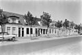 Street view


References[edit]
- ^ a b c "Kerncijfers wijken en buurten 2021". Central Bureau of Statistics. Retrieved 20 April 2022.
- ^ "Postcodetool for 4484AA". Actueel Hoogtebestand Nederland (in Dutch). Het Waterschapshuis. Retrieved 20 April 2022.
- ^ "Kortgene - (geografische naam)". Etymologiebank (in Dutch). Retrieved 20 April 2022.
- ^ a b c Piet van Cruyningen & Ronald Stenvert (2003). Kortgene (in Dutch). Zwolle: Waanders. ISBN 90 400 8830 6. Retrieved 20 April 2022.
- ^ a b "Kortgene". Zalig Zeeland (in Dutch). Retrieved 20 April 2022.
- ^ "Kortgene". Plaatsengids (in Dutch). Retrieved 20 April 2022.
- ^ Ad van der Meer and Onno Boonstra, Repertorium van Nederlandse gemeenten, KNAW, 2011.
External links[edit]
 Media related to Kortgene at Wikimedia Commons