Kyauktan Township
Appearance
Kyauktan Township
ကျောက်တန်း မြို့နယ် | |
|---|---|
Township of Yangon Region | |
| Coordinates: 16°38′17″N 96°19′22″E / 16.63806°N 96.32278°E | |
| Country | |
| Region | |
| Township | Kyauktan |
| Population (2014) | 132,765 |
| Time zone | UTC6:30 (MST) |
| Area code(s) | 1 (mobile: 80, 99) |
| [1] | |
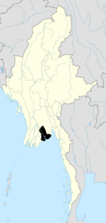
Kyauktan Township (Template:Lang-my [tɕaʊʔtáɰ̃ mjo̰nɛ̀]) is a township of Yangon Region, located in the southern section of the region.[2]
Prominent People from Kyauktan Township
- Dr. Than Nyein (5 August 1936 – 21 May 2014), founder of National Democratic Force Party, was born in Khanaung east village.[3]
References
- ^ Union Census Report. The 2014 Myanmar Population and Housing Census. Vol. 2. Naypyidaw: Ministry of Immigration and Population. May 2015. p. 61.
- ^ "Profile of Kyauktan Township" (PDF). Myanmar Information Management Unit (MIMU). April 2009. Retrieved 2011-02-19. [dead link]
- ^ "NDF leader Dr Than Nyein dies of lung cancer". www.elevenmyanmar.com. 2014-05-22. Archived from the original on 2014-05-22. Retrieved 2014-07-02.
External links
- "Kyauktan Township" map, Myanmar Information Management Unit (MIMU) [dead link]


