Le Croisic
Le Croisic
Ar Groazig | |
|---|---|
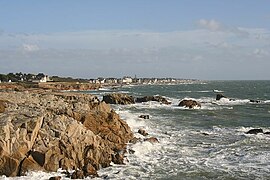
 La côte sauvage. | |
| Coordinates: 47°17′38″N 2°30′33″W / 47.2939°N 2.5092°W | |
| Country | France |
| Region | Pays de la Loire |
| Department | Loire-Atlantique |
| Arrondissement | Saint-Nazaire |
| Canton | La Baule-Escoublac |
| Intercommunality | Cap Atlantique |
| Government | |
| • Mayor (2008–2014) | Michèle Quellard |
| Area 1 | 4.5 km2 (1.7 sq mi) |
| Population (2006[1]) | 4,121 |
| • Density | 920/km2 (2,400/sq mi) |
| • Urban | 70,248 |
| Demonym(s) | Croisicais, Croisicaise |
| Time zone | UTC+01:00 (CET) |
| • Summer (DST) | UTC+02:00 (CEST) |
| INSEE/Postal code | 44049 /44490 |
| Elevation | 0–20 m (0–66 ft) (avg. 5 m or 16 ft) |
| Website | http://www.lecroisic.fr/ |
| 1 French Land Register data, which excludes lakes, ponds, glaciers > 1 km2 (0.386 sq mi or 247 acres) and river estuaries. | |
Le Croisic (Breton: Ar Groazig), is a commune in the Loire-Atlantique department in western France. The United States Navy established a naval air station on 27 November 1917 to operate seaplanes during World War I. The base closed shortly after the First Armistice at Compiègne.[2] The writer and historian Auguste Lorieux (1796–1842) was born in Le Croisic.
See also
References
- ^ données officielles 2006 sur le site de l’INSEE
- ^ Van Wyen, Adrian O. (1969). Naval Aviation in World War I. Washington, D.C.: Chief of Naval Operations. p. 45.
Wikimedia Commons has media related to Le Croisic.


