Madagali
Madagali | |
|---|---|
LGA and town | |
| Coordinates: 10°44′46″N 13°24′57″E / 10.74611°N 13.41583°E | |
| Country | |
| State | Adamawa State |
| Time zone | UTC+1 (WAT) |
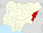
Madagali or Madagli is a town and local government area in Adamawa State, Nigeria. The LGA was created in 1991 when Taraba State was created out of Gongola State. It borders Michika to the north, Askira uba to the west, Gwoza local government area to the south and the Republic of Cameroon to the east. There are many ethnic groups but Marghi and Fulani are the major ethnic languages.
In September 2012, a Boko Haram commander was killed in Madgali by Nigerian government forces, and 156 arrests were made as a part of "Operation Restore Sanity."[1]
The town was seized by Boko Haram in August 2014. In September 2014, residents of Madagali, Gulak and Michika fled to mountainous areas and Mubi town, in the wake of a failed attempt by government troops to re-take the town from the insurgents.[2]
References
- ^ Onah, Matthew (2012-09-24). "Nigeria: Boko Haram Kingpin Shot Dead in Adamawa". This Day - allAfrica.com. Retrieved 2014-10-21.
- ^ "Nigeria: Thousands Flee as Boko Haram Militants Seize Major Towns". Retrieved 2014-10-21.


