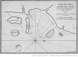
Matemo Island
Appearance
This article needs additional citations for verification. (April 2024) |
Native name: Kisiwa cha Matemo | |
|---|---|
 | |
| Geography | |
| Coordinates | 12°13′S 40°35′E / 12.22°S 40.59°E |
| Archipelago | Quirimbas Islands |
| Area | 24 km2 (9.3 sq mi) |
| Administration | |
Mozambique | |
Matemo Island (Kisiwa cha Matemo, in Swahili) forms part of the pristine Quirimbas Islands and is located northeast of Ibo island, in northern Mozambique,[1] about 100 km from the city of Pemba. It is approximately 24 square kilometres in area, with palm groves and beaches.
It contains five villages, inhabited by native Mozambicans, as well as the Matemo Island Resort, falling within the Rani Resorts group.
References
[edit]- ^ "UNICEF and UN CERF work together to support the education of displaced children in Cabo Delgado | UNICEF Mozambique". www.unicef.org. Retrieved 2024-04-12.
External links
[edit]Wikivoyage has a travel guide for Matemo Island.
