Nunton
| Nunton | |
|---|---|
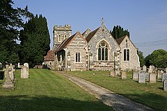
 Church of St Andrew, Nunton | |
Location within Wiltshire | |
| OS grid reference | SU158261 |
| Civil parish | |
| Unitary authority | |
| Ceremonial county | |
| Region | |
| Country | England |
| Sovereign state | United Kingdom |
| Post town | SALISBURY |
| Postcode district | SP5 |
| Dialling code | 01722 |
| Police | Wiltshire |
| Fire | Dorset and Wiltshire |
| Ambulance | South Western |
| UK Parliament | |
Nunton is a small village and former civil parish in Wiltshire, England, about 2.5 miles (4.0 km) southeast of Salisbury. The former parish included the small village of Bodenham, 0.6 miles (0.97 km) to the east.[1]
Nunton is on the River Ebble, while Bodenham is close to the junction of the Ebble and the Hampshire Avon. The A338 primary route (linking Salisbury with the south coast) separates the two villages.[2]
Local government
Nunton and Bodenham were a tithing of Downton parish. In the 19th century it was deemed to be a separate civil parish, then in 1934 the villages were transferred to Odstock parish.[3]
Landmarks
The Anglican Church of St Andrew at Nunton is Grade II* listed.[4] It has 12th-century origins but was rebuilt in 1854-55 by T.H. Wyatt. There is a window by Christopher Webb.[5] Nunton House, built in around 1720, is also Grade II* listed.[6]
North of Bodenham is the Longford Castle estate, seat of the Pleydell-Bouverie family, Earls of Radnor.[7] There is a 15th-century thatched pub at Nunton, the Radnor Arms.[8]
Notable people
- John Creasey (1908–1973), author, died at New Hall Hospital, Bodenham[9]
- William Henry Goddard (1795–1872), merchant in Gambia, was born at Nunton[10]
Bordering areas
References
- ^ "Nunton, Wiltshire". A vision of Britain through time. University of Portsmouth. Retrieved 23 March 2015.
- ^ "Nunton" (Map). Google Maps. Retrieved 4 September 2016.
- ^ "Victoria County History - Wiltshire - Vol 11 pp19-77 - Parishes: Downton". British History Online. University of London. Retrieved 23 March 2015.
- ^ "Church of St. Andrew, Nunton". Wiltshire Community History. Wiltshire Council. Retrieved 23 March 2015.
- ^ Historic England. "Church of St Andrew, Nunton, Odstock (1181836)". National Heritage List for England. Retrieved 23 March 2015.
- ^ Historic England. "Nunton House (1181829)". National Heritage List for England. Retrieved 23 March 2015.
- ^ Jones' Views of the Seats, Mansions, Castles, Etc. of Noblemen and Gentlemen in England:: Accompanied with Historical Descriptions of the Mansions, Lists of Pictures, Statues, &c. and Genealogical Sketches of the Families, of Their Possessors: Forming Part of the General Series of Jones' Great Britain Illustrated, ... Jones & Company. 1829. p. 140.
- ^ Anderson, Jane (28 June 2013). Dorset, New Forest & Isle of Wight Footprint Focus Guide: Includes Stonehenge, Salisbury & Winchester. Footprint Travel Guides. p. 47. ISBN 978-1-909268-20-3.
- ^ "John Creasey". Fantastic Fiction. Retrieved 6 December 2021.
{{cite web}}: CS1 maint: url-status (link) - ^ Perfect, David (27 May 2016). Historical Dictionary of The Gambia. Rowman & Littlefield Publishers. p. 187. ISBN 978-1-4422-6526-4.
External links
- "Odstock". Wiltshire Community History. Wiltshire Council. Retrieved 23 March 2015.
![]() Media related to Nunton, Wiltshire at Wikimedia Commons
Media related to Nunton, Wiltshire at Wikimedia Commons

