
Occagnes
Occagnes | |
|---|---|
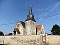
.jpg) The church of Saint-Gervais et Saint-Protais of Occagnes | |
Location of Occagnes  | |
 Occagnes  Occagnes | |
| Coordinates: 48°46′45″N 0°04′17″W / 48.7792°N 0.0714°W | |
| Country | France |
| Region | Normandy |
| Department | Orne |
| Arrondissement | Argentan |
| Canton | Argentan-1 |
| Intercommunality | Argentan Intercom |
| Government | |
| • Mayor (2020–2026) | Karine Bourdelas[1] |
| Area 1 | 15.56 km2 (6.01 sq mi) |
| Population (2021)[2] | 675 |
| • Density | 43/km2 (110/sq mi) |
| Time zone | UTC+01:00 (CET) |
| • Summer (DST) | UTC+02:00 (CEST) |
| INSEE/Postal code | 61314 /61200 |
| Elevation | 160–244 m (525–801 ft) (avg. 177 m or 581 ft) |
| 1 French Land Register data, which excludes lakes, ponds, glaciers > 1 km2 (0.386 sq mi or 247 acres) and river estuaries. | |
Occagnes (French pronunciation: [ɔkaɲ] ⓘ) is a commune in the Orne department in north-western France.
Geography[edit]
The commune is made up of the following collection of villages and hamlets, Pommainville, La Petite Rue,Cuy and Occagnes.[3]
The commune has the River Houay and one of its tributaries the Ruisseau des Fontaines Thiot running through it.[4]
Notable buildings and places[edit]
National heritage sites[edit]
The Commune has 2 buildings and areas listed as a Monument historique
- Château de Cuy a 17th Century Chateau in Occagnes registered as a Monument historique in 1936.[5]
- Church of Cuy is an 11th Century Church that is an example of the first Romanesque art.[6]
-
 Château de Cuy (Occagnes)
 -
 Vestiges de l’église Saint-Cyr et Sainte-Julitte d’Occagnes (Pommainville)
 -
 Church of Cuy - as photographed by Milka-berger
.jpg)
.jpg)

See also[edit]
References[edit]
- ^ "Répertoire national des élus: les maires". data.gouv.fr, Plateforme ouverte des données publiques françaises (in French). 9 August 2021.
- ^ "Populations légales 2021". The National Institute of Statistics and Economic Studies. 28 December 2023.
- ^ a b "Occagnes · 61200, France". Occagnes · 61200, France.
- ^ Sandre. "Fiche cours d'eau - L'Houay (I2129000)".
- ^ "Château de Cuy à Occagnes - PA00110878". monumentum.fr.
- ^ "Eglise de Cuy à Occagnes - PA00110879". monumentum.fr.
Wikimedia Commons has media related to Occagnes.
| Authority control databases: National |
|---|
This Orne geographical article is a stub. You can help Wikipedia by expanding it. |