
Pamban Bridge
Pamban Bridge பாம்பன் பாலம் | |
|---|---|
 Pamban Road and Rail Bridge | |
| Coordinates | 9°16′57.25″N 79°12′5.91″E / 9.2825694°N 79.2016417°E |
| Carries | 2 lanes of road traffic |
| Crosses | Palk Strait |
| Locale | Rameswaram, Tamil Nadu, India |
| Location | |
 | |
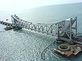
The Pamban Bridge is a railway bridge on the Palk Strait which connects the town of Rameswaram on Pamban Island to mainland India. The bridge refers to both the road bridge and the cantilever railway bridge, though primarily it means the latter. Opened on 24 February 1914, it was India's first sea bridge, and was the longest sea bridge in India until the opening of the Bandra-Worli Sea Link in 2010. The rail bridge is, for the most part, a conventional bridge resting on concrete piers, but has a double leaf bascule section midway, which can be raised to let ships and barges pass through.

History


The railway bridge is 6,776 ft (2,065 m) long.[1] It was opened on 24 February 1914, construction having begun in 1911. However, plans for a bridge had been suggested from as early as 1870 as the British Administration sought ways to increase trade with Ceylon.[2] The bridge has a still-functioning double-leaf bascule section that can be raised to let ships pass.
The adjacent road bridge was opened in 1988.[2]
The railway bridge historically carried metre gauge trains, but Indian Railways upgraded the bridge to carry broad gauge trains as part of Project Unigauge,[2] work that was completed on 12 August 2007.[3] Until recently, the two leaves of the bridge were opened manually using levers by workers.[1] Around 10 ships — cargo carriers, coast guard ships, fishing vessels and oil tankers — pass through the bridge every month.[2] More work was carried out on the bridge in 2009 to strengthen it to enable it to carry goods trains.[2]
After completion of the bridge, metre-gauge lines were laid from Mandapam up to Pamban station. From here the railway line bifurcated, one line towards Rameshwaram about 6.25 miles (10.06 km) up and another branch line of 15 miles (24 km) terminating at Dhanushkodi. The section was opened to traffic in 1914.[4][5] The Ministry of Indian Railways sanctioned Rs. 25 crore to replace the existing 65.23-meter- long rolling type span, which opened like a pair of scissors to allow the vessels to pass the bridge with 66-meter-long single truss span which could be opened with the press of the button.[6]
The noted Boat Mail ran on this track between 1915 and 1964 from Madras-Egmore up to Dhanushkodi, from where the passengers were ferried to Talaimannar in Ceylon. The metre-gauge branch line from Pamban Junction to Dhanushkodi was abandoned after it was destroyed by the 1964 Dhanushkodi cyclone.[7]
The bridge was subsequently restored to working conditions under Elattuvalapil Sreedharan in just 46 days.[8] On 13 January 2013 the bridge suffered minor damage when a naval barge drifted into it. The tug towing a naval barge from Kolkata to Karwar near Mumbai ran aground hitting rocks on 10 January during bad weather. The 220 tonne barge then drifted into the bridge causing part of it to tilt slightly and requiring repair work to the piers.[9] In 2013 it was reported that Indian Railways had applied to UNESCO for the bridge to be made a world heritage site.[2]
Location
The bridge spans a 2 km-strait between mainland and island and is the only surface transport link between the two. The mainland end of the bridge is located at 9°16′56.70″N 79°11′20.12″E / 9.2824167°N 79.1889222°E.
According to Indian Railways' chief construction engineer, the bridge is located in the world's second most corrosive environment after Florida, making its maintenance a challenging job. The location is also a cyclone-prone high wind velocity zone.[1] The bridge consist of 143 piers and the centre span is a Scherzer rolling type lift span. Each half of the lifting span weighs 415 tonnes.[10]
-
 Until recently, the bridge formed Pamban island's only link with the Indian mainland. Thousands of Hindu pilgrims on pilgrimage to the holy Hindu shrine of Rameswaram cross the bridge every day
 -
 Pamban Bridge, Rameshwaram
 -
 Rail Bridge from Indian mainland to Rameshwaram
 -
 Pamban Bridge, Rameshwaram
 -
 Pamban Bridge
 -
 Inaugural plaque
 -
Pamban Bridge in Rameswaram


See also
- Bandra–Worli Sea Link
- List of longest bridges in the world
- List of longest bridges above water in India
References
- ^ a b c Raja Simhan T.E. (21 November 2003). "Pamban Bridge to be pulled down for gauge conversion". The Hindu. Retrieved 7 May 2015.
- ^ a b c d e f "Pamban bridge: 10 awesome facts about India's first sea bridge". The Economic Times.
- ^ http://economictimes.indiatimes.com/slideshows/infrastructure/pamban-bridge-10-awesome-facts-about-indias-first-sea-bridge/new-broad-gauge-line-in-2007/slideshow/25683681.cms?from=mdr
- ^ Nanji Bapa ni Nondh-pothi. Dharsibhai Jethalal Tank, compiler. Vadodara, Gujarat. 1999. p. 29.
Pamban Bridge Contractors: Built by Manji Daya Vegad & Lakhu Devji Vegad of Anjar & Gangji Narayan of Khedoi started works in 1887 for South Indian Railway. Also built Neel-Mandir at Rameshwaram.
{{cite book}}: CS1 maint: location missing publisher (link) CS1 maint: others (link) This book is a diary of Railway Contracts done by Mistris of Kutch noted by Nanji Govindji Tank of Jamshedpur. (This book was given Aank Sidhhi award by Kutch Shakti at Mumbai in 2000.) - ^ Jethwa, Raja Pawan (2007). "Section II: Mileage wise available Details of Railway lines laid". Shree Kutch Gurjar Kshatriya Samaj: A brief History & Glory of our fore-fathers. pp. 63–70.
- ^ The Hindu
- ^ C. Jaishankar (17 July 2006). "Their sentiment to metre gauge train is unfathomable". The Hindu.
- ^ "Delhi's Subway Builder". Forbes. 1 May 2009.
- ^ "Repair work on Pamban bridge fast progressing". The Hindu. 16 January 2013.
- ^ Papri Sri Raman (11 August 2007). "Bridge of memories - and to Rameswaram - reopens". Hindustan Times.