
Remoray-Boujeons
Remoray-Boujeons | |
|---|---|
 Église Saint-Anne | |
Location of Remoray-Boujeons  | |
 Remoray-Boujeons  Remoray-Boujeons | |
| Coordinates: 46°46′06″N 6°14′23″E / 46.7683°N 6.2397°E | |
| Country | France |
| Region | Bourgogne-Franche-Comté |
| Department | Doubs |
| Arrondissement | Pontarlier |
| Canton | Frasne |
| Government | |
| • Mayor (2020–2026) | Jean-Marie Pourcelot[1] |
| Area 1 | 15.15 km2 (5.85 sq mi) |
| Population (2021)[2] | 446 |
| • Density | 29/km2 (76/sq mi) |
| Time zone | UTC+01:00 (CET) |
| • Summer (DST) | UTC+02:00 (CEST) |
| INSEE/Postal code | 25486 /25160 |
| Elevation | 849–1,166 m (2,785–3,825 ft) |
| 1 French Land Register data, which excludes lakes, ponds, glaciers > 1 km2 (0.386 sq mi or 247 acres) and river estuaries. | |
Remoray-Boujeons is a commune in the Doubs department in the Bourgogne-Franche-Comté region in Eastern France. In 2018, it had a population of 428.
Population
| Year | Pop. | ±% |
|---|---|---|
| 1962 | 242 | — |
| 1968 | 256 | +5.8% |
| 1975 | 220 | −14.1% |
| 1982 | 184 | −16.4% |
| 1990 | 210 | +14.1% |
| 1999 | 284 | +35.2% |
| 2008 | 323 | +13.7% |
| 2012 | 381 | +18.0% |
Gallery
-
 The Lac de Remoray and Labergement-Sainte-Marie seen from Remoray-Boujeons
 -
 View of Remoray
 -
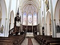 Inside of Église Sainte-Anne in Remoray
 -
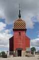 Église de la Nativité-de-la-Vierge in Boujeons
 -
 Inside of the Église de la Nativité-de-la-Vierge


See also
References
- ^ "Répertoire national des élus: les maires" (in French). data.gouv.fr, Plateforme ouverte des données publiques françaises. 13 September 2022.
- ^ "Populations légales 2021" (in French). The National Institute of Statistics and Economic Studies. 28 December 2023.
Wikimedia Commons has media related to Remoray-Boujeons.
| International | |
|---|---|
| National | |