
Santec
Santec
Santeg | |
|---|---|
 Île de Sieck seen from Dossen Beach, in Santec | |
 Coat of arms | |
Location of Santec  | |
 Santec  Santec | |
| Coordinates: 48°42′16″N 4°01′33″W / 48.7044°N 4.0258°W | |
| Country | France |
| Region | Brittany |
| Department | Finistère |
| Arrondissement | Morlaix |
| Canton | Saint-Pol-de-Léon |
| Government | |
| • Mayor (2020–2026) | Bernard Le Pors[1] |
| Area 1 | 8.06 km2 (3.11 sq mi) |
| Population (2021)[2] | 2,400 |
| • Density | 300/km2 (770/sq mi) |
| Time zone | UTC+01:00 (CET) |
| • Summer (DST) | UTC+02:00 (CEST) |
| INSEE/Postal code | 29273 /29250 |
| Elevation | 0–41 m (0–135 ft) |
| 1 French Land Register data, which excludes lakes, ponds, glaciers > 1 km2 (0.386 sq mi or 247 acres) and river estuaries. | |
Santec (French pronunciation: [sɑ̃tɛk]; Breton: Santeg) is a commune in the Finistère department of Brittany in north-western France.
Population[edit]
Inhabitants of Santec are called in French Santecois.
| Year | Pop. | ±% p.a. |
|---|---|---|
| 1968 | 2,032 | — |
| 1975 | 2,019 | −0.09% |
| 1982 | 2,147 | +0.88% |
| 1990 | 2,208 | +0.35% |
| 1999 | 2,133 | −0.38% |
| 2007 | 2,278 | +0.83% |
| 2012 | 2,328 | +0.44% |
| 2017 | 2,409 | +0.69% |
| Source: INSEE[3] | ||
Sights[edit]
-
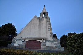
 Saint Adrien church
 -
 Saint Claude chapel
 -
 Île de Sieck
 -
 Dossen beach
 -
 Dune
Dune


See also[edit]
References[edit]
- ^ "Répertoire national des élus: les maires". data.gouv.fr, Plateforme ouverte des données publiques françaises (in French). 2 December 2020.
- ^ "Populations légales 2021". The National Institute of Statistics and Economic Studies. 28 December 2023.
- ^ Population en historique depuis 1968, INSEE
External links[edit]
Wikimedia Commons has media related to Santec.
- Official website (in French)
- Base Mérimée: Search for heritage in the commune, Ministère français de la Culture. (in French)
- Mayors of Finistère Association (in French)
| International | |
|---|---|
| National | |
| Geographic | |
This Finistère geographical article is a stub. You can help Wikipedia by expanding it. |