
Sint-Martens-Latem
This article needs additional citations for verification. (January 2013) |
Sint-Martens-Latem | |
|---|---|
 | |
 Flag  Coat of arms | |
Location of Sint-Martens-Latem  | |
| Country | |
| Community | Flemish Community |
| Region | Flemish Region |
| Province | East Flanders |
| Arrondissement | Ghent |
| Government | |
| • Mayor | Agnes Lannoo (Welzijn) |
| • Governing party/ies | Welzijn |
| Area | |
| • Total | 14.45 km2 (5.58 sq mi) |
| Population (2018-01-01)[1] | |
| • Total | 8,468 |
| • Density | 590/km2 (1,500/sq mi) |
| Postal codes | 9830, 9831 |
| NIS code | 44064 |
| Area codes | 09 |
| Website | www.sint-martens-latem.be |
Sint-Martens-Latem (Dutch pronunciation: [sɪnt ˌmɑrtəns ˈlaːtəm]) is a municipality located in the Belgian province of East Flanders, in Belgium. The municipality comprises the towns of Deurle and Sint-Martens-Latem proper. On January 1, 2006, Sint-Martens-Latem had a total population of 8,280. The total area is 14.34 km² which gives a population density of 577 inhabitants per km².
While "Latem" used to be known as an artists' colony before World War II, nowadays Sint-Martens-Latem is one of the wealthiest residential municipalities in Belgium.
Famous inhabitants
- Brigitta Callens, ex Miss Belgium, Model & Yoga Teacher
- Luc-Peter Crombé, painter
- Gustave De Smet, painter
- Edgar Gevaert, painter
- George Minne, sculptor and artist
- Constant Permeke, painter
- Gustave Van de Woestijne, painter
- Rudolf Werthen, violinist & conductor
Gallery
-
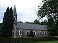 Sint-Aldegondischurch in Deurle
 -
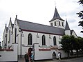 Sint-Martinuschurch in Sint-Martens-Latem
 -
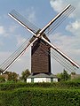 Koutermolen, Latemse Molen, Sint-Baafsmolen, a post mill


References
- ^ "Wettelijke Bevolking per gemeente op 1 januari 2018". Statbel. Retrieved 9 March 2019.
External links
 Media related to Sint-Martens-Latem at Wikimedia Commons
- Template:Nl icon Official website
| Aalst |  | |
|---|---|---|
| Dendermonde | ||
| Eeklo | ||
| Ghent | ||
| Oudenaarde | ||
| Sint-Niklaas | ||
| ||
This East Flanders location article is a stub. You can help Wikipedia by expanding it. |