
Surxondaryo Region
Surkhondaryo Region
Surxondaryo viloyati Сурхондарё вилояти Сурхандарьинская область | |
|---|---|
 Mausoleum of Hakim al-Termezi in Termez | |
 Surxondaryo in Uzbekistan | |
| Coordinates: 38°0′N 67°30′E / 38.000°N 67.500°E | |
| Country | Uzbekistan |
| Capital | Termez |
| Government | |
| • Hokim | Ulug‘bek Qosimov[1] |
| Area | |
| • Total | 20,099 km2 (7,760 sq mi) |
| Elevation | 535 m (1,755 ft) |
| Population (2021)[2] | |
| • Total | 2,680,800 |
| • Density | 130/km2 (350/sq mi) |
| Time zone | UTC+5 (East) |
| ISO 3166 code | UZ-SU |
| Districts | 14 |
| Cities | 8 |
| Townships | 7 |
| Villages | 114 |
| Website | www |
Surxondaryo Region (Uzbek: Surxondaryo viloyati, Сурхондарё вилояти, Russian: Сурхандарьинская область, Persian: سرخاندریا, UniPers: "sorxāndaryā"), old spelling Surkhandarya Region is a region (viloyat) of Uzbekistan, located in the extreme south-east of the country. Established on March 6, 1941, it borders on Qashqadaryo Region internally, and Turkmenistan, Afghanistan and Tajikistan externally, going anticlockwise from the north. It takes its name from the river Surxondaryo, that flows through the region. It covers an area of 20,100 km².[3] The population is estimated at 2,743,201 (beginning of 2022 data), with 80% living in rural areas.[4][5] According to official data, 83% of the population are Uzbeks and 12,5% Tajiks,[6] but several sources argue that the Tajik population might be significantly higher in this region (Bitter debates accompanied the Soviet allocation of Surkhandarya Region to the Uzbek SSR rather than the Tajik SSR in 1929, as that region, as well as the areas of Bukhara and Samarkand, had sizable, if not dominant, Tajik populations) , as well as in Samarkand and Bukhara.[7][full citation needed][better source needed] The highest point of the Region and also of Uzbekistan is Khazrati Sulton peak reaching 4,643 m/15,233 ft in Gissar Range.[8]
The regional capital is Termez with a population of 122,900 (2021),[2] and the second largest city is Denov (Denau) with 69,500 inhabitants (data for 2005).[5] Other towns include Boysun, Jarqoʻrgʻon, Qumqoʻrgʻon, Shargʻun, Sherobod, Shoʻrchi, and Sariosiyo.
The climate is continental, with mild wet winters and hot dry summers. The southern part of the region is in the Badkhiz-Karabil semi-desert ecoregion (PA0808), characterized by a savanna of pistachio and desert sedge. The northern portion is characterized by open woodlands (Gissaro-Alai open woodlands ecoregion, PA1306), with characteristic plants being pistachio, almond, walnut, apple, and juniper. Sagebrush is common at lower elevations [9][10]

Natural resources include petroleum, natural gas, and coal. Light industry, mainly cotton ginning and food processing, is also an important part of the regional economy, particularly in the production of consumer goods. Agriculture is based primarily on cotton and cereals, supplemented with horticulture and viticulture. Surxondaryo is the country's largest supplier of long-fiber cotton. Livestock accounts for 40% of regional agricultural product.[5] The climatic conditions of this region also make it possible to cultivate subtropical crops such as sugarcane.
The region has a well-developed transport infrastructure, with 300 km of railways and 2,700 km of surfaced roads.[5] Central Asia's only river port is located at Termez on the Amudarya River.
History[edit]
Bitter debates accompanied the Soviet allocation of Surkhandarya Region to the Uzbek SSR rather than the Tajik SSR in 1929, as that region, as well as the areas of Bukhara and Samarkand, had sizable, if not dominant, Tajik populations.[citation needed]
Districts[edit]

The Surxondaryo Region consists of 14 districts (listed below) and one district-level city: Termez.[3][11]
| District name | District capital | |
|---|---|---|
| 1 | Angor District | Angor |
| 2 | Bandixon District | Bandixon |
| 3 | Boysun District | Boysun |
| 4 | Denov District | Denov (Denau) |
| 5 | Jarqoʻrgʻon District | Jarqoʻrgʻon |
| 6 | Qiziriq District | Sariq |
| 7 | Qumqoʻrgʻon District | Qumqoʻrgʻon |
| 8 | Muzrabot District | Xalqobod (Khalkabad) |
| 9 | Oltinsoy District | Qarluq |
| 10 | Sariosiyo District | Sariosiyo |
| 11 | Sherobod District | Sherobod |
| 12 | Shoʻrchi District | Shoʻrchi |
| 13 | Termiz District | Uchqizil |
| 14 | Uzun District | Uzun |
There are 8 cities (Termez, Boysun, Denov, Jarqoʻrgʻon, Qumqoʻrgʻon, Shargʻun, Sherobod, Shoʻrchi) and 112 urban-type settlements in the Surxondaryo Region.[3][11]
Agriculture (2005 data)[edit]
Agriculture accounts for 42% of total employment in Surxondaryo Region and produces 8% of Uzbekistan’s agricultural output. Agricultural production is 56% crops and 44% livestock (like the country’s average). Milk yields are less than 1,700 kg per cow per year, on a par with the national average.
Main characteristics of agriculture in Surxondaryo Region[5][12]
| Surxondaryo | Percent of national total | |
|---|---|---|
| Sown area | 278,100 ha | 8 |
| Cereals | 45% | 8 |
| Cotton | 45% | 8 |
| Potatoes, vegetables | 5% | 7 |
| Feed crops | 5% | 5 |
| Fruit orchards | 12,600 ha | 6 |
| Vineyards | 8,400 ha | 6 |
| Cattle | 531,100 head | 8 |
| Cows | 241,900 head | 9 |
| Sheep, goats | 1,253,500 head | 11 |
Gallery[edit]
-
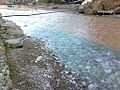 Two different streams flow into one (a healing spring and the river itself in blue)
 -
 Market at the foot of Khujaypok
 -
 Healing bath from a hydrogen-chloride source. Treats infectious skin diseases and difficult to heal wounds
 -
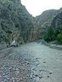 The Khujaypok river
,_Surkhandarya,_Uzbekistan-12.jpg)
,_Surkhandarya,_Uzbekistan-15.jpg)
,_Surkhandarya,_Uzbekistan-14.jpg)
,_Surkhandarya,_Uzbekistan-16.jpg)
References[edit]
- ^ "Ulug'bek Qosimov Surxondaryo viloyati hokimi etib tasdiqlandi". 13 March 2023.
- ^ a b "Urban and rural population by district" (PDF) (in Uzbek). Surxondaryo regional department of statistics.
- ^ a b c "Oʻzbekiston Respublikasining maʼmuriy-hududiy boʻlinishi" [Administrative-territorial division of the Republic of Uzbekistan] (in Uzbek). The State Committee of the Republic of Uzbekistan on statistics. July 2021. Archived from the original on 4 February 2022.
- ^ "Ўзбекистонда энг кўп аҳоли қайси вилоятда яшайди?". Qalampir.uz (in Uzbek). Retrieved 2022-02-11.
- ^ a b c d e Statistical Yearbook of the Regions of Uzbekistan 2005, State Statistical Committee, Tashkent, 2006 (Russian).
- ^ Ethnic composition of the population in Surxondaryo Region
- ^ Lena Jonson (1976) "Tajikistan in the New Central Asia", I.B.Tauris, p. 108: "According to official Uzbek statistics there are slightly over 1 million Tajiks in Uzbekistan or about 3% of the population. The unofficial figure is over 6 million Tajiks. They are concentrated in the Sukhandarya, Samarqand and Bukhara regions."
- ^ Ethnic Atlas of Uzbekistan Archived 2008-10-06 at the Wayback Machine, Part 1: Ethnic minorities, Open Society Institute, table with number of Tajiks by region (in Russian).
- ^ World Wildlife Fund, ed. (2001). "Gissaro-Alai open woodlands". WildWorld Ecoregion Profile. National Geographic Society. Archived from the original on 2010-03-08.
- ^ World Wildlife Fund, ed. (2001). "Badkhiz-Karabil semi-desert". WildWorld Ecoregion Profile. National Geographic Society. Archived from the original on 2010-03-08.
- ^ a b "Classification system of territorial units of the Republic of Uzbekistan" (in Uzbek and Russian). The State Committee of the Republic of Uzbekistan on statistics. July 2020.
- ^ Agriculture in Uzbekistan, State Statistical Committee, Tashkent, 2007 (Russian).
External links[edit]
- Map of Surxondaryo Region (Russian).
Places adjacent to Surxondaryo Region | |
|---|---|
Capital: Termez | ||
| Districts |  | |
| Cities | ||
| Towns | ||