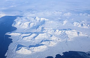
Sørkapp Land
Appearance

Sørkapp Land is the land area south of Hornsund, at the southern part of Spitsbergen, Svalbard.[1] Two glaciers, Hornbreen and Hambergbreen, divide Sørkapp Land from Torell Land.[2][3]
Sørkapp Land is included in the Sør-Spitsbergen National Park.
References
- ^ "Sørkapp Land". Norwegian Polar Institute. Retrieved 15 November 2011.
- ^ "Hornbreen". Norwegian Polar Institute. Archived from the original on 11 July 2012. Retrieved 15 November 2011.
- ^ "Hambergbreen". Norwegian Polar Institute. Archived from the original on 16 July 2012. Retrieved 15 November 2011.
76°48′00″N 16°45′00″E / 76.8000°N 16.7500°E
