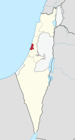
Tel Aviv District
Tel Aviv District | |
|---|---|
| - transcription(s) | |
| • Hebrew | Template:Hebrew |
 | |
| Cities | 10 |
| Local Councils | 2 |
| Regional Councils | 0 |
| Capital | Tel Aviv |
| Area | |
| • Total | 186 km2 (72 sq mi) |
| Population (2014) | |
| • Total | 1,350,000 |
The Tel Aviv District (Template:Lang-he-n) is the smallest and most densely populated of six administrative districts of Israel with a population of 1.2 million residents.[1] It is 99.0% Jewish and 1.0% Arab (0.7% Muslim, 0.3% Christian)[citation needed]. It is also the only of the six districts to simultaneously not border the West Bank, Gaza Strip, or any international border, instead being surrounded on the north, east, and south by the Central District and on the west by the Mediterranean Sea. The population density of Tel Aviv district is 7,258/km2.
The district's capital is Tel Aviv and the metropolitan area created by the Tel Aviv district and its neighboring cities is locally named Gush Dan.
Administrative sub-regions
| Cities | Local Councils |
|---|---|

List of cities and towns in Tel Aviv district
| Pop Rank | Name | Population | Land Area (Dunams) | Founded | City Since |
|---|---|---|---|---|---|
| 1 | Tel Aviv | 404,400 | 51,788 | 1909 | 1921 |
| 2 | Holon | 184,700 | 18,927 | 1940 | 1950 |
| 3 | Bnei Brak | 172,000 | 7,343 | 1924 | 1950 |
| 4 | Ramat Gan | 148,035 | 13,229 | 1921 | 1950 |
| 5 | Bat Yam | 129,100 | 8,167 | 1926 | 1958 |
| 6 | Herzliya | 84,400 | 21,850 | 1924 | 1960 |
| 7 | Giv'atayim | 49,800 | 3,246 | 1922 | 1959 |
| 8 | Ramat HaSharon | 38,200 | 16,792 | 1923 | 2002 |
| 9 | Or Yehuda | 32,400 | 5,141 | 1949 | 1988 |
| 10 | Kiryat Ono | 28,400 | 4,112 | 1939 | 1992 |
| 11 | Azor | 11,701 | 2,415 | 1948 | |
| 12 | Kfar Shmaryahu | 1,769 | 2,665 | 1937 | |
| 13 | Glil Yam (Hof HaSharon RC) | 432 | - | 1943 | |
| 14 | Mikveh Israel | 394 | - | 1870 |
See also
References
External links
![]() Media related to Tel Aviv District at Wikimedia Commons
Media related to Tel Aviv District at Wikimedia Commons
32°05′N 34°48′E / 32.083°N 34.800°E

