
User:Spitzmauskc/sandbox1

You can help expand this article with text translated from the corresponding article in Finnish. (December 2017) Click [show] for important translation instructions.
|
Vanhakylä
Gammalby Vanha-Ulvila | |
|---|---|
District of Ulvila | |
 Ulvilan kirkonseutu with the Ulvila Church (right) and the Mynsteri residential area | |
| Etymology: 'Old Village' or 'Old Ulvila' | |
| Country | |
| Region | |
| Sub-region | Pori sub-region |
| Municipality | Ulvila |
| Sub-district areas |
|
| Population (2015) | |
| • Total | 4,326 |
Vanhakylä (Swedish: Gammalby, lit. 'Old Village') or Vanha-Ulvila (lit. 'Old Ulvila') is a district of Ulvila municipality in the Pori sub-region of Satakunta in southwestern Finland. The Kokemäenjoki divides the town centre of Ulvila into two parts – the eastern half is located on the northern bank of the Kokemäenjoki in Vanhakylä and the western half is located in the district of Friitala, on the river's southern bank.
The medieval town of Ulvila was located in the modern district of Vanhasakylä, from which the district's name is derived. Situated outside of the core of Vanhasakylä, the Ulvila Church is the only remaining building from the medieval settlement. The Ulvila Church and surroundings were designated a Cultural Heritage Site of National Significance by the Finnish Heritage Agency in 2009.[1]
Geography[edit]
During the 12th to 14th centuries, the estuary of the Kokemäenjoki was located in Ulvila and different harbors operated over the centuries in what is now the Vanhakylä district.
History[edit]
In Muhammad al-Idrisi's 1154 CE text accompanying his world map – together known as the Tabula Rogeriana – three settlements are identified in the lands of Finnmark and Tabast, interpreted by some scholars as the Finnish regions of Southwest Finland (Swedish: Egentliga Finland, Finnish: Varsinais-Suomi) and Tavastia (Swedish: Tavastland, Finnish: Häme), respectively. Both regions and the settlement of Abrarah'm in Tavastia are featured in the world map. Evaluation of the Tabula Rogeriana, particularly of areas far removed from the well-mapped Arab world, faces a number of hurtles, including distortion of many place names to suit Arabic phonology and substantial geographic inaccuracies. As a result, all interpretations regarding Finland are controversial.
In the lands of Finnmark, al-Idrisi notes the settlements of Abrarah'm and Vehmaar, and in Tabast, Regoldah. Abrarah'm is the only one of the three locations noted in both the text and the map and there is general consensus that it is Åbo (Finnish: Turku), a significant settlement since at least the Iron Age.[4][5] The locations of the other two sites named in the text are highly contested. In the early 20th century, linguist O.J. Tuulio identified Regoldah as referring to Ravani (Swedish: Ragvaldsby), which he posited was located at Liikistö in the southwestern part of Vanhakylä's modern core at that time.[6] Historian Jalmari Jaakkola, a contemporary of Tuulio's, rejected the idea and others have connected Regoldah to Rauma
Liikistö[edit]
The historical record of early settlement in Ulvila is severely limited, as most decrees, certificates, and letters related to the medieval settlement were destroyed in the Pori fire of 1698. A surviving index of documents, made during the 17th century, provides some limited historical context and, combined with archaeological research, enables a concept of medieval Ulvila to be formed.
The earliest record of settlement in the area was a letter by Ragvald II, Bishop of Åbo from 1311, regarding the construction of a church at Liikistö.(REA264) Archaeological study has provided evidence of a wooden church at Liikistö in the 13th century and supports the hypothesis that a church may have existed by the first decade of the 13th century, which would make it the third-oldest church site in Finland after Ravattula Church in Kaarina and Koroinen Church in the Koroinen district of Turku.[7] Nearly 300 of the graves at Liikistö cemetery were excavated in the 1930s by a team led by Ilkka Kronqvist and, based on material findings and positioning of the hands, the cemetery was determined to have been in use during the 13th to 15th centuries.(Kronqvist 1932, 36; Kronqvist 1938, 54–56; Jäkärä 2000)
Liikistö appears in the historical record again in a 1332 order issued by Bishop Bengt of Turku, which concerned the building of a stone church at Liikistö (de Templo lapideo in Lijkis).(REA 402) The foundation of a stone church was constructed but work on the building was abandoned and it was left unfinished.[8] The Kokemäenjoki receded around Liikistö during the late 13th and early 14th century, resulting in a shift of settlement and trade 1.5 kilometres (0.93 mi) downstream to the medieval town of Ulvila and it has been suggested that construction of the stone church at Liikistö was abandoned as urban life relocated away from Liikistö and it fell out of use. Elements of the stone foundation walls can still be seen at Liikistö and a memorial cross has been erected within the unfinished building's outline.[9]

Bits[edit]
Direct access to the sea made the settlement's trading post one of the two most important markets in the region, along with Kokemäki (Teljä).[1]
The medieval town of Ulvila was situated in Vanhakylä and received town rights in 1365.[10] Ulvila's town rights were transferred to Pori in 1558, after the shoreline and harbor shifted downstream due to post-glacial rebound.[1]
Liikistö[edit]
The earliest significant
The first town church in Ulvila was built in the area of Liikistö, a trade post some 1.5 kilometres (0.93 mi) east of what later became the medieval settlement of Ulvila, and belonged to the Kokemäki parish until the independent Ulvila parish was founded (by 1344 at the latest).[11] Historian Ilkka Kronqvist suggested a church existed in Liikistö by the early years of the 13th century, which would make it the third-oldest church site in Finland after Ravattula Church in Kaarina and Koroinen Church in the Koroinen district of Turku.[7]
Most decrees, certificates, and letters related to the early history of Ulvila and Liikistö were destroyed in the Pori fire of 1698 but a surviving index of documents provides some limited context regarding the early churches in the area. The earliest record was an order issued by Ragvald II, Bishop of Åbo in 1311, which concerned the building of a stone church at Liikistö. The foundation of a stone church was constructed but work on the building was abandoned and it was left unfinished.[8] Elements of the stone foundation walls can still be seen at Liikistö and a memorial cross has been erected within the unfinished building's outline.[9]
Archaeological excavations at Liikistö during the 1930s, led by Kronqvist, revealed many grave markers and carved stone pavers in the church cemetery. A stone monument that had once been standing was also found in the area, with a shape similar to the Kalevanpoika scythe-stick that stands in the churchyard of St. Peter's Church in the village of Untamala, Laitila.[12] Kronqvist also mentioned the discovery of coins from the 13th and 14th centuries in a 1938 report. A total of 298 graves have been found in the cemetery and radiocarbon analysis of the graves supports the theory that the cemetery was in use from the first half of the 1200s through the 1300s.[13]
Further excavations during 2002 to 2003 identified the remains of a burnt wooden wall in the corner of the cemetery, where the church was thought to have been located. Radiocarbon dating of the material dated the building to the 14th century. Furthermore, colored glass was found in the fill of graves below the wall line, suggesting a building with colored glass windows was present before the construction of the building that formed the wall trace. Thus, it is quite possible that Kronqvist's hypothesis was correct and an earlier chapel stood at the site in the 1200s.
Medieval Ulvila[edit]

Sub-district areas[edit]
The Kokemäenjoki divides the town centre of Ulvila into two parts – the western portion is located in the district of Friitala, on the southern bank of the Kokemäenjoki, and the eastern portion in Vanhakylä, on the northern bank of the Kokemäenjoki.
Transport[edit]

The districts are linked along connecting road 2442 via the Friitalan silta (lit. 'Friitala Bridge'). Built in 1952, when demand for crossing exceeded the capacity of the existing ferry services,[14] the original Friitalan silta was demolished in 2017 and the new Friitalan silta was completed in 2018.[15] The bridge supports bidirectional traffic with a vehicle lane in either direction, features wide sidewalks on both sides, and sees an avaerage of 8,300 auto crossings per day.[15][16]
Connecting road 2442 meets connecting road 2440 in the core of Vanhakylä. Connecting road 2440 has a different name to the north and south of connecting road 2442. To the north, connecting road 2440 is called the Kirkkotie (lit. 'Church road') because it directly passes the Ulvila Church. The area north of the core of Vanhakylä along the Kirkkotie, which includes the Ulvila Church, is called the Ulvilan kirkonseutu (lit. 'church area of Ulvila'). The area is generally sparsely populated but includes the Mynsteri residential area where, among other things, the home pitch of the football club FC Ulvila is located.
Location[edit]
Vanhakylä is surrounded by countryside to the north, east, and south, with the Kokemäenjoki defining its western edge and separating the district from the Friitala district of Ulvila to the west and the Harmaalinna district of Pori to the north-west. The closest neighboring settlements on the northern bank of the Kokemaenjoki are villages and hamlets within the Ulvila municipality that lie to the north, south, and east of Vanhakylä, separated from Vanhakylä's residential areas by fields and forests.

To the north is the village of Harjunpää, which has an approximate population of 1,500 and lies 8.1 kilometres (5.0 mi) from Vanhakylä's core. To get to Harjunpää from Vanhakylä, one travels via connecting road 2440 as it becomes connecting road 2553 north of Mynsteri and passes through the hamlets of Suosmeri (Swedish: Svartsmark) and Sunniemi (Swedish: Sonnäs), 4.6 km (2.9 mi) and 6.2 km (3.9 mi) north of Vanhakylä respectively. About 1 kilometre (0.62 mi) to the south of Vanhakylä's core is the village of Ravani (Swedish: Ragvaldsby); the portion of connecting road 2440 running south of connecting road 2442 towards Ravani is called the Ravanintie (lit. 'Ravani road'). To the east is the village of Kaasmarkku (Swedish: Karlsmark), which had a population of 585 in 2015 and lies about 8 kilometres (5.0 mi) from the centre of Vanhakylä along the Kaasmarkuntie (lit. 'Kaasmarku road').

To the north-west of the core of Vanhakylä and west of the Ulvilan kirkonseutu is Saarenluoto (lit. 'Saari islet'; Swedish: Mullholmen), an approximately three-kilometre (1.9 mi) long island formed by the Kokemäenjoki and one of its minor branches, the Kirkkojuopa. There are three bridges across the Kirkkojuopa between Saarenluoto and Vanhakylä: a wooden bridge connects the Ulvila Church to the Saari manor,[17] a wooden suspension bridge connects Mynsteri to the nature trails of Ulvila's outdoor municipal recreation area on Saarenluoto,[18] [19] and a bridge along Highway 11, which runs just north of Mynsteri. On its western side, Saarenluoto is linked to Pori over the Kokemäenjoki by Highway 11.
Historical sites[edit]
The Ulvila Church and surroundings, which include the vicar's parsonage Gammelgård, the Isokartano manor and Saari manor, the Trumetari estate, and the Liikistö historical area, were designated a Cultural Heritage Site of National Significance by the Finnish Heritage Agency in 2009.[1]
Gallery[edit]
-
 Aerial view of the Mukulamäki area, the northern part of Vanhakylä's core
 -
 Aerial view of the Palonpää area, the southeastern part of Vanhakylä's core
 -
 The old Friitalan silta over the Kokemäenjoki in 2012, looking across the river at Friitala from Vanhakylä.
 -
 The Kirkkojuopaa with Saarenluoto on the right
 -
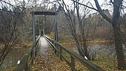 Eeron silta ('Eero's bridge') connecting Mynsteri to the nature trails on Saarenluoto
 -
 Saaren kartano ('Saari manor') on Saarenluoto


References[edit]
- Hiekkanen, Markus (1994). The Stone Churches of the Medieval Diocese of Turku: A Systematic Classification and Chronology (Doctoral dissertation). Translated by Kokkonen, Jüri. Helsinki: Suomen Muinaismuistoyhdistys [Finnish Antiquarian Society]. ISBN 9789519057118.
- Hiekkanen, Markus (2000). "Ulvilan kirkon ikä". SARKA – Satakunnan Museon Vuosikirja 2000 (in Finnish). Pori: Satakunnan Museo. ISSN 1238-9668.
- Hiekkanen, Markus (2001). Satakunnan keskiaikaiset kivikirkot (in Finnish). Vammala: Kotiseutututkimuksia XIX. pp. 194–212.
- Hiekkanen, Markus (2003). Suomen keskiajan kivikirkot (in Finnish) (1st ed.). Helsinki: Kustannusosakeyhtiö Otava.
- Hiekkanen, Markus (2014). Suomen keskiajan kivikirkot (in Finnish) (3rd ed.). Helsinki: Suomalaisen Kirjallisuuden Seura. ISBN 9789522226006.
- Hirsjärvi, Tarmo (1932). Ulvilan seurakunta (in Finnish). Forssa: Ulvilan seurakunta.
- Lehtinen, Erkki; Kopisto, Aarne; Virkkala, Kalevi (1967). Suur-Ulvilan historia I (PDF) (in Finnish). Pori: Porin maalaiskunnan, Ulvilan, Kullaan ja Nakkilan kunnat. Retrieved 5 September 2022.
- Suvanto, Seppo (1973). Satakunnan historia III: keskiaika (in Finnish). Pori: Satakunnan maakuntaliitto. ISBN 951950950X. Retrieved 5 September 2022.
- Tulkki, Carita (2006). Ulvilan kirkko ja tapuli: Ulvilan kirkon ja tapulin restaurointi- ja korjaustyön arkeologinen valvonta 2004–2005 (in Finnish). Pori: Satakunnan Museo. Retrieved 5 September 2022.
- Avellan, Niilo J. (1928). "Entisen Ulvilan pitäjän maatilat II: Vanhakylä". Satakunta - Kotiseutututkimuksia III (in Finnish) (2nd ed.). Satakuntalainen osakunta. pp. 115–121.
Notes[edit]
- ^ a b c d "Valtakunnallisesti merkittävät rakennetut kulttuuriympäristot (RKY): Ulvilan kirkko ja ympäristö" (in Finnish). Museovirasto. 22 December 2009. Retrieved 5 October 2022.
- ^ O, J (26 November 2016). "Baltic Magus-Land on Idrisi map of 1154 CE". S K É D N I S E. Retrieved 25 November 2022.
- ^ "Suomi maailmankartalla". Tunturisusi.com (in Finnish). Retrieved 25 November 2022.
- ^ Masonen, Jaakko (1991). Hämeen Härkätie. Helsinki: Otava. pp. 186–190. ISBN 9511114212.
- ^ "Suomen historian merkkipaaluja: Ensimmäisenä Turussa". Turun kaupunki (in Finnish). 15 August 2019. Retrieved 29 October 2022.
- ^ Tuulio, O.J. (1936). "Satakunnan vanhin tunnettu paikannimi". Satakunta-sarja (PDF) (in Finnish). Vammala: Tyrvään Kirjapaino Oy. pp. 32–43. Retrieved 29 October 2022.
- ^ a b Suvanto 1973, p. 19.
- ^ a b Lehtinen, Kopisto & Virkkala 1967, p. 20–25.
- ^ a b Salminen, Tapio (2007). Kokemäen ja Harjavallan historia: Joki ja sen väki – Kokemäen ja Harjavallan historia jääkaudesta 1860-luvulle (in Finnish). Jyväskylä: Kokemäen ja Harjavallan kaupungit ja seurakunnat. pp. 165–169. ISBN 9789529994106.
- ^ Suvanto 1973, p. 280–282.
- ^ Hiekkanen 2014, p. 266–269.
- ^ "Untamala village road". Laitilan kaupunki. Retrieved 5 September 2022.
- ^ Sjölund, Anna-Kaisa (2000). "Ulvilan Liikistön varhaisvaiheista". SARKA – Satakunnan Museon Vuosikirja 2000 (in Finnish). Pori: Satakunnan Museo: 86–99. ISSN 1238-9668.
- ^ Jääskeläinen, Sanna (May 2019). "Ulvilan uusi silta vihittiin käyttöön juhlavasti". Satakunnan Viikko (in Finnish). Retrieved 9 October 2022.
- ^ a b Pukkila, Tapio (29 October 2018). "Friitalan uusi jokisilta otettiin käyttöön". Yle Uutiset (in Finnish). Retrieved 9 October 2022.
- ^ Hammarberg, Ville (26 October 2018). "Ulvilalainen Anja Halenius matkasi aikoinaan nahkatehtaalle töihin lautalla, nyt kulku käy uutukaista Friitalan siltaa pitkin". Satakunnan Kansa (in Finnish). Retrieved 9 October 2022.
- ^ "Kokemäenjoki - Kirkkojuopa". Kokemaenjokiopas.fi (in Finnish). Retrieved 15 October 2022.
- ^ Esko, Laura (6 February 2020). "Saaren luontopolku". Daphnion (in Finnish). Retrieved 25 November 2022.
- ^ "Kokemäenjoki - Saarenluoto". Kokemaenjokiopas.fi (in Finnish). Retrieved 25 November 2022.
External links[edit]
- Detailed map of Vanhakylä from the National Land Survey of Finland (in Finnish)