Zone 5 of Milan
Appearance
Zona 5 di Milano | |
|---|---|
Zona of Milan | |
 | |
 Location of Zone 5 of Milan | |
 Map of Zone 5 of Milan | |
| Country | |
| Region | Lombardy |
| Province | Milan (MI) |
| Comune | Milan |
| Area | |
| • Total | 11.53 sq mi (29.87 km2) |
| Population (2006) | |
| • Total | 134,016 |
| Time zone | UTC+1 (CET) |
| • Summer (DST) | UTC+2 (CEST) |
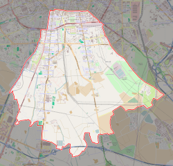
The Zone 5 of Milan (in Italian: Zona 5 di Milano) is one of the 9 administrative zones of Milan, Italy.[1] It is the southernmost zone of the city.
Subdivision
The zone includes the following quarters: Basmetto, Cantalupa, Case Nuove, Chiaravalle, Chiesa Rossa, Conca Fallata, Fatima, Gratosoglio, Le Terrazze, Macconago, Missaglia, Morivione, Porta Lodovica, Porta Vigentina, Quintosole, Ronchetto delle Rane, San Gottardo, Selvanesco, Stadera, Torretta, Vaiano Valle and Vigentino.
Notable places
References
- ^ (in Italian) The 9 city councils of Milan (municipal website)
External links
![]() Media related to Municipio 5 (Milan) at Wikimedia Commons
Media related to Municipio 5 (Milan) at Wikimedia Commons
- (in Italian) Zone 5 of Milan (municipal website)
