
Zaječov: Difference between revisions
m r2.7.3) (Robot: Removing roa-rup:Zaječov |
|||
| (27 intermediate revisions by 11 users not shown) | |||
Line 1:
{{Infobox settlement
| name = Zaječov
| other_name =
| settlement_type = [[Obec|Municipality]]
<!-- images -->
| image_skyline = Zaječov, monastery.jpg
|
| image_flag = Zaječov BE CZ flag.svg
|
<!-- location -->
|
| subdivision_name = {{CZE}}
| subdivision_type1 = [[Regions of the Czech Republic|Region]]
| subdivision_name1 = [[Central Bohemian Region|Central Bohemian]]
| subdivision_type2 = [[Districts of the Czech Republic|District]]
| subdivision_name2 = [[Beroun District|Beroun]]
<!-- maps and coordinates -->
| image_map
|
|
|
| pushpin_map_caption = Location in the Czech Republic
| coordinates = {{coord|49|46|28|N|13|50|27|E|display=inline,title}}
| coordinates_footnotes =
<!-- government type, leaders -->
| leader_title =
| leader_name =
<!-- established -->
|
| established_date = 1578
<!-- area -->
| area_footnotes =
| area_total_km2 = 22.25
<!-- elevation -->
| elevation_footnotes =
| elevation_m = 458
<!-- population -->
|
| population_footnotes = <ref>{{cite web |title=Population of Municipalities – 1 January 2023|url=https://www.czso.cz/csu/czso/population-of-municipalities-1-january-2023|publisher=[[Czech Statistical Office]]|date=2023-05-23}}</ref>
|
| population_density_km2 = auto
<!-- time zone(s) -->
| timezone1 = [[Central European Time|CET]]
|
| timezone1_DST = [[Central European Summer Time|CEST]]
|
<!-- postal codes, area code -->
| postal_code_type = Postal codes
|
| area_code_type =
|
<!-- website, footnotes -->
|
|
}}
'''Zaječov''' is a
==Administrative parts==
The villages of Kvaň and Nová Ves are administrative parts of Zaječov.
==Geography==
Zaječov is located about {{convert|25|km}} southwest of [[Beroun]] and {{convert|47|km|abbr=on}} southwest of [[Prague]]. It lies in the [[Brdy|Brdy Highlands]]. The highest point is the mountain Jordán at {{convert|826|m|ft|abbr=on}} above sea level. The southern part of the municipal territory lies in the Brdy Protected Landscape Area.
==History==
The first written mention of Zaječov is from 1578. On 1 January 1976, the municipalities of Zaječov and Kvaň were merged.<ref>{{cite web |title=Historie obce|url=https://zajecov.cz/historie/|publisher=Obec Zaječov|language=cs|access-date=2023-03-15}}</ref>
==Demographics==
{{historical populations
|align=none|cols=3
|1869|2003
|1880|1956
|1890|1927
|1900|1971
|1910|2001
|1921|1920
|1930|1896
|1950|2576
|1961|1677
|1970|1565
|1980|1415
|1991|1359
|2001|1346
|2011|1407
|2021|1445
|source=Censuses<ref>{{cite web |title=Historický lexikon obcí České republiky 1869–2011 – Okres Beroun|url=https://www.czso.cz/documents/10180/20537734/130084150202.pdf/19e60bb3-edf7-4107-808b-a3d5f156c202?version=1.2|publisher=Czech Statistical Office|pages=11–12|language=cs|date=2015-12-21}}</ref><ref>{{cite web |title=Population Census 2021: Population by sex|url=https://vdb.czso.cz/vdbvo2/faces/en/index.jsf?page=vystup-objekt-parametry&z=T&f=TABULKA&sp=A&skupId=4429&katalog=33515&pvo=SLD21001-OB-OK|work=Public Database|publisher=[[Czech Statistical Office]]|date=2021-03-27}}</ref>}}
==Transport==
There are no railways or major roads passing through the municipality.
==Sights==
The Svatá Dobrotivá Monastery was founded in 1262–1263 as the first [[Augustinians|Augustinian]] monastery in the [[Czech lands]]. The Gothic building was rebuilt in the Baroque style in the 17th century, the monastery church of the Annunciation was rebuilt in 1713–1719. In 1785, the monastery was abolished and the building converted into a rectory and a school. In 1990, the area was returned to the Augustinians.<ref>{{cite web |title=Klášter Svatá Dobrotivá|url=https://pamatkovykatalog.cz/klaster-svata-dobrotiva-2144128|publisher=National Heritage Institute|language=cs|access-date=2023-03-16}}</ref>
==Gallery==
<gallery>
Zaječov, upper common.jpg|Upper common
Zaječov, lower common 2.jpg|Lower common
Zaječov, Kvaň, upper common.jpg|The village of Kvaň
</gallery>
==References==
{{reflist}}
==External links==
{{commons category|Zaječov}}
*{{official|https://www.zajecov.cz/}}
{{Beroun District}}
{{authority control}}
{{DEFAULTSORT:Zajecov}}
[[Category:Villages in the Beroun District]]
| |||
Revision as of 11:00, 29 January 2024
Zaječov | |
|---|---|
 Svatá Dobrotivá Monastery | |
 Flag  Coat of arms | |
 Zaječov Location in the Czech Republic | |
| Coordinates: 49°46′28″N 13°50′27″E / 49.77444°N 13.84083°E | |
| Country | |
| Region | Central Bohemian |
| District | Beroun |
| First mentioned | 1578 |
| Area | |
| • Total | 22.25 km2 (8.59 sq mi) |
| Elevation | 458 m (1,503 ft) |
| Population (2023-01-01)[1] | |
| • Total | 1,448 |
| • Density | 65/km2 (170/sq mi) |
| Time zone | UTC+1 (CET) |
| • Summer (DST) | UTC+2 (CEST) |
| Postal codes | 267 62, 267 63 |
| Website | www |
Zaječov is a municipality and village in Beroun District in the Central Bohemian Region of the Czech Republic. It has about 1,400 inhabitants.
Administrative parts
The villages of Kvaň and Nová Ves are administrative parts of Zaječov.
Geography
Zaječov is located about 25 kilometres (16 mi) southwest of Beroun and 47 km (29 mi) southwest of Prague. It lies in the Brdy Highlands. The highest point is the mountain Jordán at 826 m (2,710 ft) above sea level. The southern part of the municipal territory lies in the Brdy Protected Landscape Area.
History
The first written mention of Zaječov is from 1578. On 1 January 1976, the municipalities of Zaječov and Kvaň were merged.[2]
Demographics
|
|
| ||||||||||||||||||||||||||||||||||||||||||||||||||||||
| Source: Censuses[3][4] | ||||||||||||||||||||||||||||||||||||||||||||||||||||||||
Transport
There are no railways or major roads passing through the municipality.
Sights
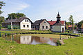
The Svatá Dobrotivá Monastery was founded in 1262–1263 as the first Augustinian monastery in the Czech lands. The Gothic building was rebuilt in the Baroque style in the 17th century, the monastery church of the Annunciation was rebuilt in 1713–1719. In 1785, the monastery was abolished and the building converted into a rectory and a school. In 1990, the area was returned to the Augustinians.[5]
Gallery
-
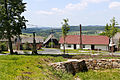
 Upper common
 -
 Lower common
 -
 The village of Kvaň


References
- ^ "Population of Municipalities – 1 January 2023". Czech Statistical Office. 2023-05-23.
- ^ "Historie obce" (in Czech). Obec Zaječov. Retrieved 2023-03-15.
- ^ "Historický lexikon obcí České republiky 1869–2011 – Okres Beroun" (in Czech). Czech Statistical Office. 2015-12-21. pp. 11–12.
- ^ "Population Census 2021: Population by sex". Public Database. Czech Statistical Office. 2021-03-27.
- ^ "Klášter Svatá Dobrotivá" (in Czech). National Heritage Institute. Retrieved 2023-03-16.
External links
| International | |
|---|---|
| National | |