
Phra Sumen Road

Phra Sumen Road (Thai: ถนนพระสุเมรุ) is a 1.3 km (0.8 mi) long road that runs through the Bangkok's old town zone known as "Rattanakosin Island".
It was named after the fort that was built since the King Buddha Yodfa Chulaloke (Rama I)'s reign, when he planted Bangkok to be the new capital in 1782. According to royal customs, forts were ordered to be constructed, altogether there were 14 citadel forts that were built, of which only two remain, there are Mahakan Fort and Phra Sumen Fort. Because the road starts from Phra Sumen Fort as the continuation of Phra Athit Road at the bank of the Chao Phraya River and meanders around the city following Khlong Rop Krung (around the city canal) up till the foot of Phan Fa Lilat Bridge where it merges Ratchadamnoen Avenue in the area opposite Mahakan Fort. Thereby giving it the name Phra Sumen.
The highlight of this road is its both sides have a number of important historical structures, ranging from the beginning on the Phra Sumen Fort side, there is an old printing press which belonged to the teacher's council, it was the first school to teach the art of pringting in Thailand. It is Kurusapa Printing House otherwise known as Wat Sangwet Printer School, currently its façade has been renovated into a Pipit Banglamphu, a museum that displays the history and way of life of Bang Lamphu folks.[1] While the opposite side there are dilapidated bricks between shophouses they are the remains of the old palace gate arbor. There is also a shrine with an image of Prince Jakjessada, the King Rama I half-younger brother, who used to have a residence in this area. In addition, the shophouses in this area have many chic restaurants and cafés, some units also offer art galleries and bookstores.[2][3]
The road passes through Bang Lamphu, an old commercial district with a long history and that is well known to Thais for being garment trading area especially school uniforms. Now it is known globally as a budget accommodation hub and hangout spot for foreign tourists, also the location of notable Khaosan Road.[1] It also passed beside of Wat Bowonniwet, the principle Buddhist temple in Dhammayuttika Nikāya order. Next to this is a neighbourhood called Saphan Wan Chat, a bridge crossing Khlong Rop Krung (section Khlong Bang Lamphu). Area at the southwestern foot of the bridge there are old shophouses, which encompassed an old trading area and the type of things on sale include national flags, flag poles, King's royal emblems, royal photographs and various emblems and symbols.[4] Opposite side are the city walls and the outer city gate, which is covered in bricks and cement. The gate has an arbor that that is made of sculpted cement and has been conserved and is in good condition.
The road continues up till the front the Queen Sirikit Gallery, part of Bangkok Bank, Phan Fa Branch, which is where it terminates.[3]
Gallery[edit]
-
 Sign of the road
 -
 The fort and the road at noon
 -
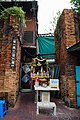 Remnants of a palace gate and shrine dedicated to Prince Jakjessada
 -
 The city wall remnants near Wat Bowonniwet


See also[edit]
References[edit]
- ^ a b Lim, Eric. "Pipit Banglamphu Museum the last Lamphu tree". Tour Bangkpk Legacies. Retrieved 2024-03-11.
- ^ Kirdsaeng, Petpailin (2018-09-21). "Exploring Phra Sumen, Khaosan's quieter neighbor". BK. Retrieved 2024-03-11.
- ^ a b Kittisrikangwan, Lily (2016-06-13). "เช้าจรดเย็น: ห่างไกลความวุ่นวายบนถนนพระสุเมรุ". SOIMILK (in Thai). Retrieved 2024-03-11.
- ^ Matichon TV (2015-06-12). "Checkin ถิ่นสยาม ตอน สะพานเฉลิมวันชาติ". YouTube (in Thai). Retrieved 2024-03-11.